
File:Darawar Fort.jpg

Size of this preview: 800 × 470 pixels. Other resolutions: 320 × 188 pixels | 640 × 376 pixels | 1,024 × 601 pixels | 1,280 × 751 pixels | 3,264 × 1,916 pixels.
Original file (3,264 × 1,916 pixels, file size: 6.09 MB, MIME type: image/jpeg)
| This is a file from the Wikimedia Commons. Information from its description page there is shown below. Commons is a freely licensed media file repository. You can help. |
Summary
| Description |
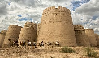
English: Derawar Fort is a large square fortress in Bahawalpur, Punjab, Pakistan. The forty bastions of Derawar are visible for many miles in the Cholistan Desert. The walls have a perimeter of 1500 metres and stand up to thirty metres high.
Українська: Караван перед фортом Даравар в місті Бахавалпур (Пакистан). Стіни по периметру мають 1500 мтерів довжини і у висоту 30 м, що робить їх видимими за кілька кілометрів в пустелі Холістан.
|
||
| Date | |||
| Source | Own work | ||
| Author | Tahsin Shah |
| Camera location | | View this and other nearby images on: OpenStreetMap |
|---|

|
This image won the tenth prize in the international finale of Wiki Loves Monuments 2016, the world's largest photo contest! |
Licensing
I, the copyright holder of this work, hereby publish it under the following license:
This file is licensed under the Creative Commons Attribution-Share Alike 4.0 International license.
- You are free:
- to share – to copy, distribute and transmit the work
- to remix – to adapt the work
- Under the following conditions:
- attribution – You must give appropriate credit, provide a link to the license, and indicate if changes were made. You may do so in any reasonable manner, but not in any way that suggests the licensor endorses you or your use.
- share alike – If you remix, transform, or build upon the material, you must distribute your contributions under the same or compatible license as the original.

|
This image was uploaded as part of Wiki Loves Monuments 2016.
|
 |

|
This image was awarded an finalist in the national contest of Pakistan in Wiki Loves Monuments 2016 Other languages:
|
File history
Click on a date/time to view the file as it appeared at that time.
| Date/Time | Thumbnail | Dimensions | User | Comment | |
|---|---|---|---|---|---|
| current | 18:44, 9 September 2016 | | 3,264 × 1,916 (6.09 MB) | Tahsin Shah | User created page with UploadWizard |
File usage
The following pages on the English Wikipedia use this file (pages on other projects are not listed):
Global file usage
The following other wikis use this file:
- Usage on ar.wikipedia.org
- Usage on azb.wikipedia.org
- Usage on bn.wikipedia.org
- Usage on ca.wikipedia.org
- Usage on de.wikipedia.org
- Usage on es.wikipedia.org
- Usage on fa.wikipedia.org
- Usage on fr.wikipedia.org
- Usage on hif.wikipedia.org
- Usage on la.wikipedia.org
- Usage on mk.wikipedia.org
- Usage on ms.wikipedia.org
- Usage on ne.wikipedia.org
- Usage on pa.wikipedia.org
- Usage on pnb.wikipedia.org
- Usage on ru.wikipedia.org
- Usage on sd.wikipedia.org
- Usage on simple.wikipedia.org
- Usage on sm.wikipedia.org
- Usage on sr.wikipedia.org
- Usage on ta.wikipedia.org
- Usage on ur.wikipedia.org
- Usage on vi.wikipedia.org