
File:Danzig-Westpreussen.png

Size of this preview: 675 × 599 pixels. Other resolutions: 270 × 240 pixels | 541 × 480 pixels | 865 × 768 pixels | 1,154 × 1,024 pixels | 1,772 × 1,573 pixels.
Original file (1,772 × 1,573 pixels, file size: 797 KB, MIME type: image/png)
| This is a file from the Wikimedia Commons. Information from its description page there is shown below. Commons is a freely licensed media file repository. You can help. |
Summary
| Description |
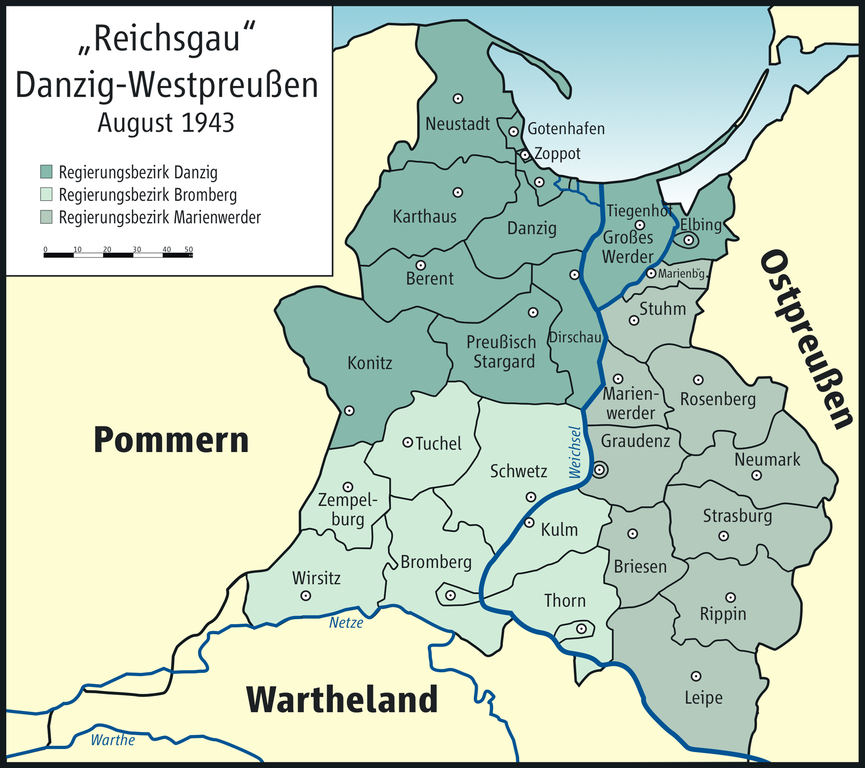
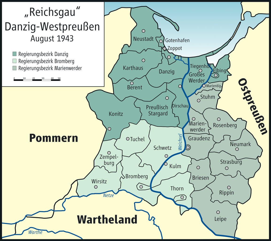
English: Map of „Reichsgau Danzig-Westpreussen“, 1943
Deutsch: Karte des „Reichsgaus Danzig-Westpreussen“, 1943 |
| Date | |
| Source | Own work |
| Author | User:ziegelbrenner |

|
This map has been made or improved in the German Kartenwerkstatt (Map Lab). You can propose maps to improve as well.
|
Licensing
| I, the copyright holder of this work, release this work into the public domain. This applies worldwide. In some countries this may not be legally possible; if so: I grant anyone the right to use this work for any purpose, without any conditions, unless such conditions are required by law. |
File history
Click on a date/time to view the file as it appeared at that time.
| Date/Time | Thumbnail | Dimensions | User | Comment | |
|---|---|---|---|---|---|
| current | 23:48, 13 October 2016 | | 1,772 × 1,573 (797 KB) | PDD | corrected "Beren" to "Berent" |
| 10:08, 23 April 2010 |  | 1,772 × 1,573 (750 KB) | Ziegelbrenner | 2010-04-23 | |
| 17:24, 27 January 2009 |  | 1,772 × 1,575 (738 KB) | Ziegelbrenner | {{Information |Description= |Source= |Date= |Author= |Permission= |other_versions= }} | |
| 14:02, 22 January 2009 |  | 1,595 × 1,417 (800 KB) | Ziegelbrenner | {{Information |Description= |Source= |Date= |Author= |Permission= |other_versions= }} | |
| 15:38, 20 January 2009 |  | 1,594 × 1,417 (605 KB) | Ziegelbrenner | {{Information |Description= |Source= |Date= |Author= |Permission= |other_versions= }} | |
| 14:35, 20 January 2009 |  | 1,594 × 1,417 (601 KB) | Ziegelbrenner | {{Information |Description= |Source= |Date= |Author= |Permission= |other_versions= }} | |
| 14:28, 20 January 2009 |  | 1,594 × 1,417 (602 KB) | Ziegelbrenner | {{Information |Description={{en|1=Map of "Reichsgau Danzig-Westpreussen", 1943}} {{de|1=Karte des "Reichsgaus Danzig-Westpreussen", 1943}} |Source=Eigenes Werk (own work) |Author=Kgberger |Date=2009-01-20 |Permission= |other_versions=unb |
File usage
The following pages on the English Wikipedia use this file (pages on other projects are not listed):
Global file usage
The following other wikis use this file:
- Usage on ar.wikipedia.org
- Usage on ca.wikipedia.org
- Usage on de.wikipedia.org
- Provinz Westpreußen
- Kreis Marienwerder
- Landkreis Elbing
- Landkreis Danzig
- Landkreis Großes Werder
- Kreis Briesen
- Landkreis Graudenz
- Landkreis Rippin (Westpr.)
- Kreis Strasburg in Westpreußen
- Kreis Löbau (Westpreußen)
- Kreis Kulm
- Kreis Schwetz
- Landkreis Thorn
- Landkreis Zempelburg
- Landkreis Bromberg
- Kreis Tuchel
- Kreis Berent
- Kreis Karthaus
- Kreis Dirschau
- Kreis Preußisch Stargard
- Kreis Neustadt in Westpreußen
- Danzig
- Landkreis Leipe (Westpr.)
- Kreis Wirsitz
- Wikipedia:Kartenwerkstatt/Archiv/2009-01
- Benutzer:Agp/Meine Bilder
- Diskussion:Regierungsbezirk Westpreußen
- Benutzer:Ziegelbrenner/Meine Bilder auf Commons
- Regierungsbezirk Marienwerder (Danzig-Westpreußen)
- Regierungsbezirk Danzig (Danzig-Westpreußen)
- Regierungsbezirk Bromberg (Danzig-Westpreußen)
- Usage on fr.wikipedia.org
- Usage on pl.wikipedia.org
View more global usage of this file.