
File:Danubemap.png
No higher resolution available.
Danubemap.png (747 × 480 pixels, file size: 601 KB, MIME type: image/png)
| This is a file from the Wikimedia Commons. Information from its description page there is shown below. Commons is a freely licensed media file repository. You can help. |

|
This map image could be re-created using vector graphics as an SVG file. This has several advantages; see Commons:Media for cleanup for more information. If an SVG form of this image is available, please upload it and afterwards replace this template with
{{vector version available|new image name}}.
It is recommended to name the SVG file “Danubemap.svg”—then the template Vector version available (or Vva) does not need the new image name parameter. |
Summary
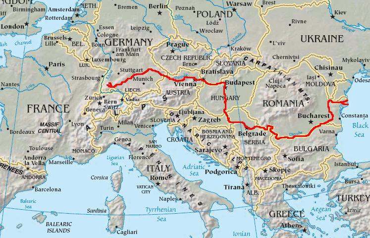
English: Map showing the flow of the Danube River. Uses the map of Europe from the CIA World Factbook.
Licensing
This image is in the public domain because it contains materials that originally came from the United States Central Intelligence Agency's World Factbook.
|
 |
File history
Click on a date/time to view the file as it appeared at that time.
| Date/Time | Thumbnail | Dimensions | User | Comment | |
|---|---|---|---|---|---|
| current | 05:34, 12 February 2007 | | 747 × 480 (601 KB) | Geologik | Map showing the flow of the Danube River. Uses the map of Europe from the CIA World Factbook. |
File usage
More than 100 pages use this file. The following list shows the first 100 pages that use this file only. A full list is available.
- Ada Kaleh
- Argeș (river)
- Baja, Hungary
- Balta Ialomiței
- Battle of Nicopolis
- Bačka Palanka
- Belene Island
- Belgrade
- Bratislava
- Breg (river)
- Brigach
- Brăila
- Budapest
- Calafat
- Cerna (Danube)
- Cernavodă
- Corabia
- Csepel Island
- Danube
- Danube–Black Sea Canal
- Danubian corridor
- Donaueschingen
- Donauinsel
- Dranova Island
- Drava
- Drobeta-Turnu Severin
- Esztergom
- Galați
- Geography of Austria
- Geography of Bulgaria
- Geography of Croatia
- Geography of Germany
- Geography of Hungary
- Geography of Moldova
- Geography of Romania
- Geography of Serbia
- Geography of Slovakia
- Geography of Ukraine
- Great Brăila Island
- Great Morava
- Great War Island
- Győr
- Hron
- Hungarian Parliament Building
- Ialomița (river)
- Iller
- Ilok
- Ingolstadt
- Inn (river)
- Internationalization of the Danube River
- Ipeľ
- Iskar (river)
- Island of Vukovar
- Island of Šarengrad
- Izmail
- Jiu (river)
- Karaš
- Kiliia
- Kozloduy Island
- Krems an der Donau
- Lech (river)
- Linz
- List of crossings of the Danube
- List of islands in the Danube
- List of tributaries of the Danube
- Lom, Bulgaria
- Margaret Island
- Morava (river)
- Nera (Danube)
- Novi Sad
- Olt (river)
- Osam
- Ostrovo (island)
- Ostrovul Ciocănești
- Ostrovul Mare, Islaz
- Passau
- Regen (river)
- Regensburg
- Reni, Ukraine
- Rhine–Main–Danube Canal
- Ruse, Bulgaria
- Sava
- Shoes on the Danube Bank
- Siret (river)
- Smederevo
- Sulina
- Széchenyi Chain Bridge
- The Horse, the Wheel, and Language
- Timiș
- Tisza
- Tulcea
- Ulm
- Vardim Island
- Vedea
- Vidin
- Vienna
- Vit (river)
- Vukovar
- Váh
- Yantra (river)
View more links to this file.
Global file usage
The following other wikis use this file:
- Usage on ang.wikipedia.org
- Usage on ast.wikipedia.org
- Usage on av.wikipedia.org
- Usage on azb.wikipedia.org
- Usage on ban.wikipedia.org
- Usage on be-tarask.wikipedia.org
- Usage on bg.wikipedia.org
View more global usage of this file.