
File:Dalian and the South Manchurian branch of the Chinese Eastern Railway.PNG
Original file (1,263 × 1,009 pixels, file size: 3.1 MB, MIME type: image/png)
| This is a file from the Wikimedia Commons. Information from its description page there is shown below. Commons is a freely licensed media file repository. You can help. |
| Description |
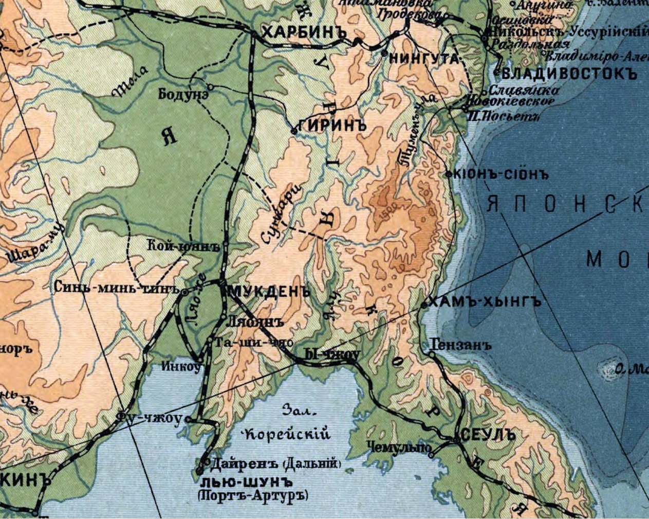
Gipsomietričieskaja karta Rossījskoj Impierīi : (opyt izobražienīja riel'iefa Impierīi) / sostavil JU. M. Šokal'skīj. Šokal'skīj, JU. M. 1856-1940. (JUlij Mihajlovič), CREATED/PUBLISHED [St. Petersburg?] : Izdanīie. Pieriesielienčieskago Upravlienīja Glavn. Upr. Ziemlieustr. i Ziemlied., [1912?] (Piečat. v kartogr. zav. Tva A.F. Marks) NOTES Relief and depths shown by gradient tints. Also shows railroads. In Russian. Pulkovo (St. Petersburg) meridian. Includes table of extreme high elevations. LC copy torn at edge, taped, inscribed in ink by the author in upper margin: The Congress Library, Washington D.C., from J. de Schokalsky in remembrance of 2 visits--1912. Scale 1:12,600,000. English: Modified file cropped version for illustrative purposes on an article - cropped version concentrated on area around Dalian and the Chinese Eastern Railway southern branch to Dalian ... Notes Харбин is en:Harbin (left of centre-top of map), Владивосток is en:Vladivostok, terminus of the transsiberian railway (top right of map), Порт-Арту is en:Port Arthur (left of bottom centre of map), Дайрэн / Дальний (Dairen/Dalian) is just north of Port Arthur |
| Date | between 1914 and 1915 |
| Source | File:Russian_Empire_Map_1912.jpg |
| Author | Yuly Mikhailovich Shokalsky |
| This is a retouched picture, which means that it has been digitally altered from its original version. The original can be viewed here: Russian Empire Map 1912.jpg: File:Russian Empire Map 1912.jpg. Modifications made by Sf5xeplus.
|
This work was published on territory of the Russian Empire (Russian Republic) except for territories of the Grand Duchy of Finland and Congress Poland before 7 November 1917 and wasn't re-published for 30 days following initial publications on the territory of Soviet Russia or any other countries.
The Russian Federation (early Soviet Russia, RSFSR) is the historical heir but not legal successor of the Russian Empire, and the Russian Empire was not party to the Berne Convention (it was not country of Union for the protection of the rights of authors in their literary and artistic works), so according to article 5 of the Convention this work has no country of origin except:
¹ - Author who is not a national of a country of the Union but who has his habitual residence in a country of the Union, be assimilated to national of that country. The exclusive rights to this work do not extend on territory of the Russian Federation according to article 1256 of the Civil Code of the Russian Federation (details), because this work does not meet the requirements on the territory of publication, on the author's nationality, and on obligations for international treaties. If applicable, {{PD-Russia-expired}} should be used instead of this tag. This work is in the public domain in the United States because it was published (or registered with the U.S. Copyright Office) before January 1, 1929. |
 |
Original upload log
This image is a derivative work of the following images:
- File:_Russian_Empire_Map_1912.jpg licensed with PD-US
- 2007-08-13T05:37:24Z Balcer 8397x6048 (11505479 Bytes) {{PD-US}}
Uploaded with derivativeFX
| Annotations | This image is annotated: View the annotations at Commons |
File history
Click on a date/time to view the file as it appeared at that time.
| Date/Time | Thumbnail | Dimensions | User | Comment | |
|---|---|---|---|---|---|
| current | 22:10, 7 February 2011 | | 1,263 × 1,009 (3.1 MB) | Sf5xeplus | {{Information |Description=Gipsomietričieskaja karta Rossījskoj Impierīi : (opyt izobražienīja riel'iefa Impierīi) / sostavil JU. M. Šokal'skīj. Šokal'skīj, JU. M. 1856-1940. (JUlij Mihajlovič), CREATED/PUBLISHED [St. Petersburg?] : Izdanīie |
File usage
Global file usage
The following other wikis use this file:
- Usage on fi.wikipedia.org
- Usage on pl.wikipedia.org