
File:Dal gCais Tribal Map.png

Size of this preview: 800 × 477 pixels. Other resolutions: 320 × 191 pixels | 640 × 381 pixels | 1,024 × 610 pixels | 1,280 × 763 pixels | 2,560 × 1,525 pixels | 3,733 × 2,224 pixels.
Original file (3,733 × 2,224 pixels, file size: 3.68 MB, MIME type: image/png)
| This is a file from the Wikimedia Commons. Information from its description page there is shown below. Commons is a freely licensed media file repository. You can help. |
Summary
| Description |
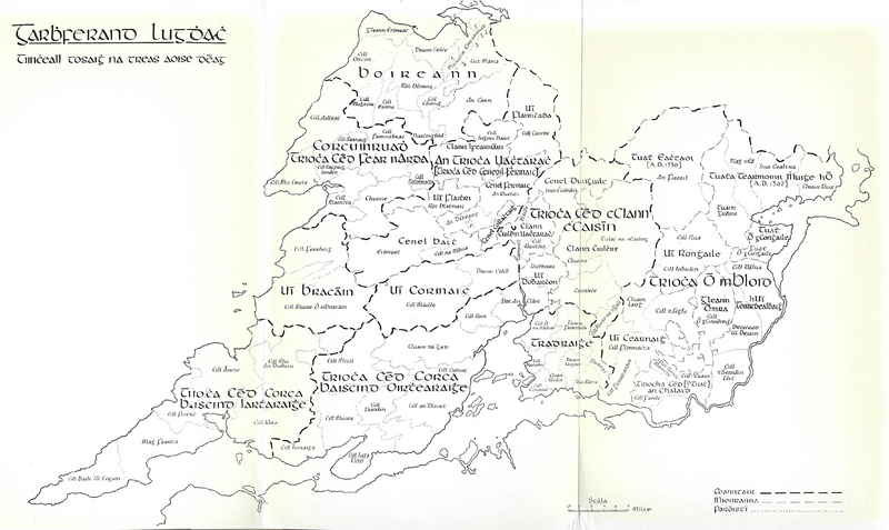
English: Clare Tribal Map 1200AD |
| Date | |
| Source | Conntae an Chláir a Trioća Agus and a Tuata |
| Author | Seán Ó hÓgáin |
Licensing
This file is licensed under the Creative Commons Attribution-Share Alike 4.0 International license.
- You are free:
- to share – to copy, distribute and transmit the work
- to remix – to adapt the work
- Under the following conditions:
- attribution – You must give appropriate credit, provide a link to the license, and indicate if changes were made. You may do so in any reasonable manner, but not in any way that suggests the licensor endorses you or your use.
- share alike – If you remix, transform, or build upon the material, you must distribute your contributions under the same or compatible license as the original.
File history
Click on a date/time to view the file as it appeared at that time.
| Date/Time | Thumbnail | Dimensions | User | Comment | |
|---|---|---|---|---|---|
| current | 19:23, 7 September 2021 | | 3,733 × 2,224 (3.68 MB) | SKIBLY101 | full |
| 06:57, 26 August 2021 |  | 1,013 × 705 (885 KB) | SKIBLY101 | Uploaded a work by John O'Donovan and Eugene O'Curry from James Frost - History and Topography of Clare OR Ordnance Survey letters from Clare by Eugene O'Curry with UploadWizard |
File usage
The following pages on the English Wikipedia use this file (pages on other projects are not listed):
Global file usage
The following other wikis use this file:
- Usage on ga.wikipedia.org