
File:DMZ in Goseong.jpg
No higher resolution available.
DMZ_in_Goseong.jpg (800 × 600 pixels, file size: 96 KB, MIME type: image/jpeg)
| This is a file from the Wikimedia Commons. Information from its description page there is shown below. Commons is a freely licensed media file repository. You can help. |
Summary
| Description |
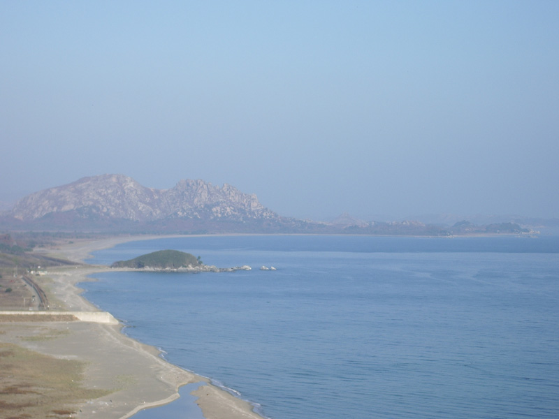
The turtle-shaped rock in the center left is the end of South Korean jurisdiction. The peaks in the distance, and the peninsula jutting to the right, are North Korea. The area in between is the Demilitarized Zone. On the peninsula there is a small village visible. I was told that it was an empty propaganda village, just like dozens of others North Korea maintains along the border. The beach looks lovely, and very inviting for a stroll. But it is safe to assume that landmines are everywhere down there, so even after permanent peace comes to the Korean peninsula, I can forget about a stroll down there. |
| Date | |
| Source | DMZ |
| Author | Rachel from Los Angeles, California, USA |
| Camera location | | View this and other nearby images on: OpenStreetMap |
|---|
Licensing
This file is licensed under the Creative Commons Attribution-Share Alike 2.0 Generic license.
- You are free:
- to share – to copy, distribute and transmit the work
- to remix – to adapt the work
- Under the following conditions:
- attribution – You must give appropriate credit, provide a link to the license, and indicate if changes were made. You may do so in any reasonable manner, but not in any way that suggests the licensor endorses you or your use.
- share alike – If you remix, transform, or build upon the material, you must distribute your contributions under the same or compatible license as the original.
| This image was originally posted to Flickr by skinnylawyer at https://www.flickr.com/photos/56619626@N05/5270813526. It was reviewed on 1 May 2011 by FlickreviewR and was confirmed to be licensed under the terms of the cc-by-sa-2.0. |
File history
Click on a date/time to view the file as it appeared at that time.
| Date/Time | Thumbnail | Dimensions | User | Comment | |
|---|---|---|---|---|---|
| current | 09:43, 1 May 2011 | | 800 × 600 (96 KB) | TKostolany | {{Information |Description=The turtle-shaped rock in the center left is the end of South Korean jurisdiction. The peaks in the distance, and the peninsula jutting to the right, are North Korea. The area in between is the Demilitarized Zone. On the peni |
File usage
The following pages on the English Wikipedia use this file (pages on other projects are not listed):
Global file usage
The following other wikis use this file:
- Usage on fr.wikipedia.org
- Usage on ko.wikipedia.org
- Usage on ms.wikipedia.org
- Usage on sv.wikipedia.org