
File:DETAIL OF DOORWAY, EAST SIDE - U. S. Military Academy, West Shore Railroad Passenger Station, West Point, Orange County, NY HABS NY,36-WEPO,1-29-3.tif

Size of this JPG preview of this TIF file: 749 × 599 pixels. Other resolutions: 300 × 240 pixels | 600 × 480 pixels | 960 × 768 pixels | 1,280 × 1,024 pixels | 2,560 × 2,048 pixels | 4,971 × 3,977 pixels.
Original file (4,971 × 3,977 pixels, file size: 18.86 MB, MIME type: image/tiff)
| This is a file from the Wikimedia Commons. Information from its description page there is shown below. Commons is a freely licensed media file repository. You can help. |
Summary
| DETAIL OF DOORWAY, EAST SIDE - U. S. Military Academy, West Shore Railroad Passenger Station, West Point, Orange County, NY | ||||
|---|---|---|---|---|
| Title |
DETAIL OF DOORWAY, EAST SIDE - U. S. Military Academy, West Shore Railroad Passenger Station, West Point, Orange County, NY |
|||
| Depicted place | New York; Orange County; West Point | |||
| Date | Documentation compiled after 1933 | |||
| Dimensions | 4 x 5 in. | |||
| Current location |
Library of Congress Prints and Photographs Division Washington, D.C. 20540 USA http://hdl.loc.gov/loc.pnp/pp.print |
|||
| Accession number |
HABS NY,36-WEPO,1-29-3 |
|||
| Credit line |
|
|||
| Notes |
|
|||
| References |
|
|||
| Source | https://www.loc.gov/pictures/item/ny1443.photos.121630p | |||
| Permission (Reusing this file) |
|
|||

| Object location | | View this and other nearby images on: OpenStreetMap |
|---|
File history
Click on a date/time to view the file as it appeared at that time.
| Date/Time | Thumbnail | Dimensions | User | Comment | |
|---|---|---|---|---|---|
| current | 17:49, 29 July 2014 | 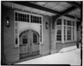 | 4,971 × 3,977 (18.86 MB) | Fæ | GWToolset: Creating mediafile for Fæ. HABS 24 July 2014 (2301:2600) |
File usage
The following pages on the English Wikipedia use this file (pages on other projects are not listed):
Global file usage
The following other wikis use this file:
- Usage on arz.wikipedia.org