
File:Currents.svg

Size of this PNG preview of this SVG file: 330 × 311 pixels. Other resolutions: 255 × 240 pixels | 509 × 480 pixels | 815 × 768 pixels | 1,087 × 1,024 pixels | 2,173 × 2,048 pixels.
Original file (SVG file, nominally 330 × 311 pixels, file size: 376 KB)
| This is a file from the Wikimedia Commons. Information from its description page there is shown below. Commons is a freely licensed media file repository. You can help. |
Summary
| Description |
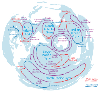
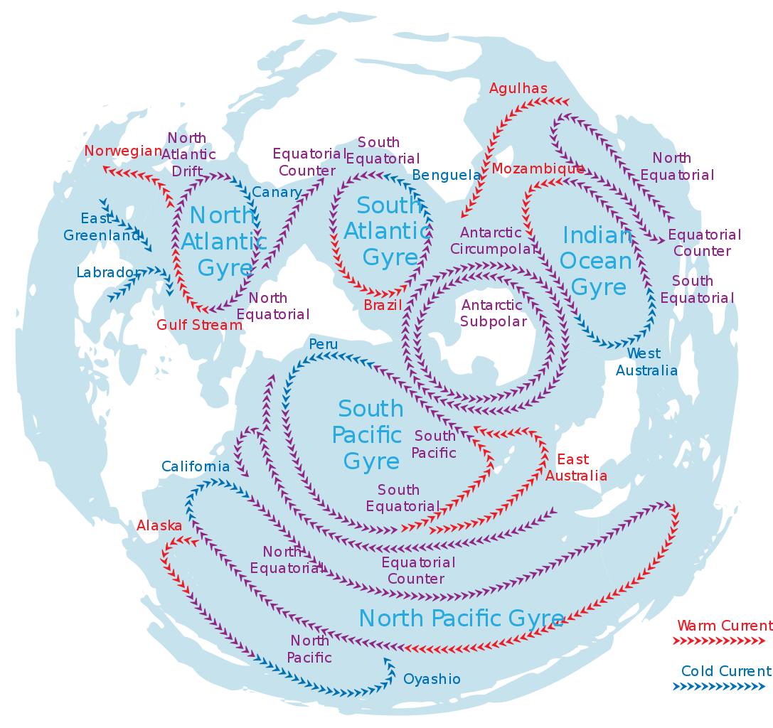
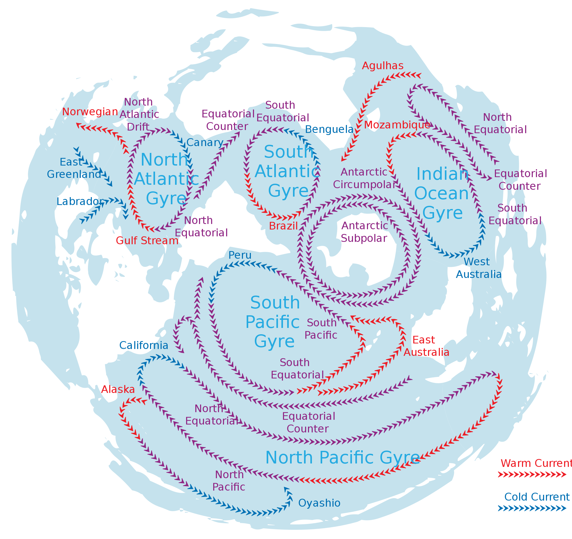
English: This is map of the worlds oceans currents and gyres based on a "dolphins perspective" that is where the oceans are shown as a single body of water and the flux can be easier understood without cutting it anywhere. This is based on a previous work of the worlds oceans.
File:Oceans-image.svg |
| Date | |
| Source | Own work |
| Author | Avsa |
| SVG development | This W3C-invalid map was created with Adobe Illustrator. |
Licensing
I, the copyright holder of this work, hereby publish it under the following licenses:
This file is licensed under the Creative Commons Attribution-Share Alike 3.0 Unported license.
- You are free:
- to share – to copy, distribute and transmit the work
- to remix – to adapt the work
- Under the following conditions:
- attribution – You must give appropriate credit, provide a link to the license, and indicate if changes were made. You may do so in any reasonable manner, but not in any way that suggests the licensor endorses you or your use.
- share alike – If you remix, transform, or build upon the material, you must distribute your contributions under the same or compatible license as the original.

|
Permission is granted to copy, distribute and/or modify this document under the terms of the GNU Free Documentation License, Version 1.2 or any later version published by the Free Software Foundation; with no Invariant Sections, no Front-Cover Texts, and no Back-Cover Texts. A copy of the license is included in the section entitled GNU Free Documentation License. |
You may select the license of your choice.
File history
Click on a date/time to view the file as it appeared at that time.
| Date/Time | Thumbnail | Dimensions | User | Comment | |
|---|---|---|---|---|---|
| current | 14:30, 6 August 2010 | | 330 × 311 (376 KB) | Shandris | removed excessive space |
| 22:18, 15 April 2010 |  | 353 × 376 (376 KB) | Seattle Skier | Corrected spelling: Antartic ---> Antarctic | |
| 21:57, 20 December 2009 |  | 353 × 376 (426 KB) | Ronhjones | Original image was too fast to the right, and chopped off some text, Used Inkscape to select whole object and manually centre in the frame | |
| 01:46, 9 November 2009 |  | 353 × 376 (345 KB) | Avsa | {{Information |Description={{en|1=This is map of the worlds oceans currents and gyres based on a "dolphins perspective" that is where the oceans are shown as a single body of water and the flux can be easier understood without cutting it anywhere. This is |
File usage
The following pages on the English Wikipedia use this file (pages on other projects are not listed):
Global file usage
The following other wikis use this file:
- Usage on ar.wikipedia.org
- Usage on az.wikipedia.org
- Usage on be.wikipedia.org
- Usage on bg.wikipedia.org
- Usage on bn.wikipedia.org
- Usage on br.wikipedia.org
- Usage on bs.wikipedia.org
- Usage on ca.wikipedia.org
- Usage on crh.wikipedia.org
- Usage on de.wikipedia.org
- Usage on en.wikiquote.org
- Usage on en.wikiversity.org
- Usage on es.wikipedia.org
- Usage on eu.wikipedia.org
- Usage on fa.wikipedia.org
- Usage on fr.wikipedia.org
- Usage on gl.wikipedia.org
- Usage on hi.wikipedia.org
- Usage on id.wikipedia.org
- Usage on it.wikipedia.org
- Usage on ko.wikipedia.org
- Usage on la.wikipedia.org
- Usage on mk.wikipedia.org
- Usage on ml.wikipedia.org
- Usage on mr.wikipedia.org
- Usage on nn.wikipedia.org
- Usage on no.wikipedia.org
- Usage on no.wiktionary.org
- Usage on pl.wikipedia.org
- Usage on pl.wikiquote.org
- Usage on pl.wiktionary.org
- Usage on pt.wikipedia.org
- Usage on ro.wikipedia.org
- Usage on ru.wikipedia.org
- Usage on simple.wikipedia.org
- Usage on sl.wikipedia.org
View more global usage of this file.