
File:Cullen Auld Kirk - geograph.org.uk - 248927.jpg
Cullen_Auld_Kirk_-_geograph.org.uk_-_248927.jpg (640 × 466 pixels, file size: 268 KB, MIME type: image/jpeg)
| This is a file from the Wikimedia Commons. Information from its description page there is shown below. Commons is a freely licensed media file repository. You can help. |
In 1851 Cullen was a Civil parish in the presbytery of Fordyce, en:Banffshire. refer: http://www.cullen-deskford-church.org.uk/deskford-castle.php
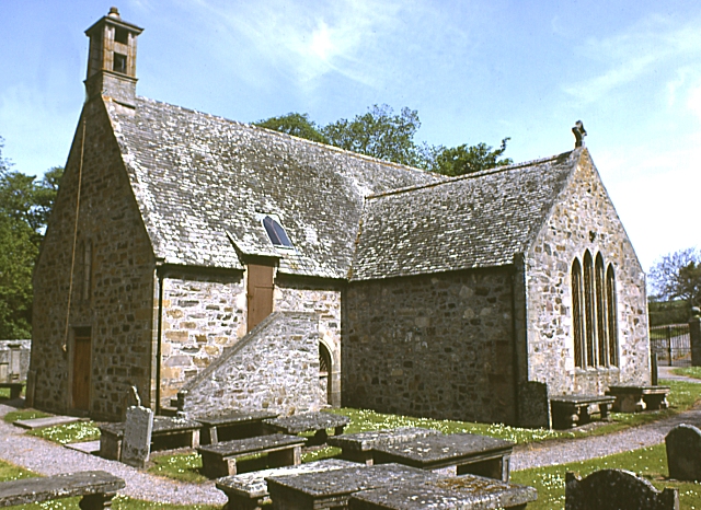
Cullen Church was known to have existed in 1236. The south aisle was added by Elena Hay in 1536 and dedicated to St Anne. It became a collegiate church in 1543 with 6 prebendaries and 2 singing boys to sing mass 'decently and in order every day'. Cullen Church was the centre of the old kirkton of Cullen until 1820-30 when township removed to present 'new town' of Cullen and the manse, which had been close by, rebuilt. ( see http://www.moraypresbytery.org.uk/churches/cullendeskford.html )
The church was founded as a chapel by King Robert Bruce. (see: https://archive.org/stream/imperialgazettee01wils#page/328/mode/2up )
The organs of en: Elizabeth de Burgh, the wife of en:Robert the Bruce are said to have been buried in its old kirk after her death in the area. Robert the Bruce made an annual payment to the village in gratitude for the treatment of his wife's body and its return south for burial.
A recent non-payment of this sum by the government was challenged and settled to the village's favour.
Writing in around 139-161, en:Ptolemy in his Geography mentions the River Celnius in the North East of Scotland. en:Both William Forbes Skene and en:George Chalmers identified the Celnius with Cullen Burn. (see: W. Cramond The Annals of Cullen, 1904)
The first mention of Cullen in Scottish history was in 962 when King Indulf was killed by the Norwegians (and/or Danes) at the mouth of the river Cullen (see: Anderson, Early Sources of Scottish History 1922 p 470 ) and referred to as the en:Battle of the Bauds. "Atween Coedlich and the sea, There lies Kings' sons three." Legend has it that within the vicinity, a Scots, a Danish and a Norwegian King are buried, marked by the three isolated rocks within Cullen Bay and named the "Three Kings". However, it is possible that these rocks derive their name from the similarity of the name Cullen with Culane (Cologne) as in the medieval mystery play "The Three Kings of Culane". (see: http://ads.ahds.ac.uk/catalogue/adsdata/PSAS_2002/pdf/vol_031/31_216_223.pdf W. CRAMOND; NOTES ON TUMULI IN CULLEN DISTRICT; AND NOTICE OF THE DISCOVERY OF TWO URNS AT FOULFORD, NEAR CULLEN (1897) Retrieved 29-12-2010 )
Summary
| Description |
English: Cullen Auld Kirk. A recent listed building report by Historic Scotland is at http://hsewsf.sedsh.gov.uk/hslive/hsstart?P_HBNUM=2218 |
| Date | |
| Source | From geograph.org.uk |
| Author | Anne Burgess |
| Attribution (required by the license) | Anne Burgess / Cullen Auld Kirk / |
| Camera location | | View this and other nearby images on: OpenStreetMap |
|---|
_region:GB-GBN_heading:45.00&language=en)
| Object location | | View this and other nearby images on: OpenStreetMap |
|---|
_region:GB-GBN_heading:45.00&language=en)
Licensing

|
This image was taken from the Geograph project collection. See this photograph's page on the Geograph website for the photographer's contact details. The copyright on this image is owned by Anne Burgess and is licensed for reuse under the Creative Commons Attribution-ShareAlike 2.0 license.
|
- You are free:
- to share – to copy, distribute and transmit the work
- to remix – to adapt the work
- Under the following conditions:
- attribution – You must give appropriate credit, provide a link to the license, and indicate if changes were made. You may do so in any reasonable manner, but not in any way that suggests the licensor endorses you or your use.
- share alike – If you remix, transform, or build upon the material, you must distribute your contributions under the same or compatible license as the original.
File history
Click on a date/time to view the file as it appeared at that time.
| Date/Time | Thumbnail | Dimensions | User | Comment | |
|---|---|---|---|---|---|
| current | 23:32, 31 January 2010 | | 640 × 466 (268 KB) | GeographBot | == {{int:filedesc}} == {{Information |description={{en|1=Cullen Auld Kirk. A recent listed building report by Historic Scotland is at http://hsewsf.sedsh.gov.uk/hslive/hsstart?P_HBNUM=2218}} |date=1983-06-18 |source=From [http://www.geograph.org.uk/photo/ |
File usage
Global file usage
The following other wikis use this file:
- Usage on de.wikipedia.org
- Usage on www.wikidata.org