
File:Cretaceous seaway.png
No higher resolution available.
Cretaceous_seaway.png (250 × 301 pixels, file size: 111 KB, MIME type: image/png)
| This is a file from the Wikimedia Commons. Information from its description page there is shown below. Commons is a freely licensed media file repository. You can help. |
Summary
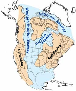
| Description | Map of North America highlighting the shallow inland seaways present during the mid-Cretaceous period. |
| Date | |
| Source | https://web.archive.org/web/20050115222718/climweb.cr.usgs.gov/research/fossils/ammonites.html |
| Author | By William A. Cobban and Kevin C. McKinney, USGS. (Image has been slightly modified by uploader to remove "CO" state designation.) |
| Other versions | Arabic, Seaway SVG and Continent labeled SVG |
Licensing
This image is in the public domain in the United States because it only contains materials that originally came from the United States Geological Survey, an agency of the United States Department of the Interior. For more information, see the official USGS copyright policy.
|

|
File:Western Interior Seaway - 95Ma (with ancient continents).svg is a vector version of this file. It should be used in place of this PNG file when not inferior.
File:Cretaceous seaway.png → File:Western Interior Seaway - 95Ma (with ancient continents).svg
For more information, see Help:SVG. |
.svg) |
File history
Click on a date/time to view the file as it appeared at that time.
| Date/Time | Thumbnail | Dimensions | User | Comment | |
|---|---|---|---|---|---|
| current | 05:35, 23 October 2013 | | 250 × 301 (111 KB) | Kwamikagami | add names of land masses |
| 05:00, 4 March 2005 |  | 250 × 301 (101 KB) | Hadal~commonswiki | from the USGS |
File usage
The following pages on the English Wikipedia use this file (pages on other projects are not listed):
Global file usage
The following other wikis use this file:
- Usage on ar.wikipedia.org
- Usage on be-tarask.wikipedia.org
- Usage on bg.wikipedia.org
- Usage on bs.wikipedia.org
- Usage on ca.wikipedia.org
- Usage on cs.wikipedia.org
- Usage on de.wikipedia.org
- Usage on es.wikipedia.org
- Usage on eu.wikipedia.org
- Usage on fa.wikipedia.org
- Usage on fr.wikipedia.org
- Usage on gl.wikipedia.org
- Usage on he.wikipedia.org
- Usage on hu.wikipedia.org
- Usage on id.wikipedia.org
- Usage on it.wikipedia.org
View more global usage of this file.