
File:Countries which no-fly-zone area was applied in their area.svg

Size of this PNG preview of this SVG file: 800 × 405 pixels. Other resolutions: 320 × 162 pixels | 640 × 324 pixels | 1,024 × 518 pixels | 1,280 × 647 pixels | 2,560 × 1,295 pixels | 856 × 433 pixels.
Original file (SVG file, nominally 856 × 433 pixels, file size: 1.15 MB)
| This is a file from the Wikimedia Commons. Information from its description page there is shown below. Commons is a freely licensed media file repository. You can help. |
| Description |
עברית: מדינות שבהן הוחל אזור האסור לטיסה בעבר
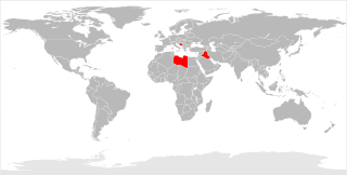
English: Countries previously subject to no-fly zones
Français : Pays s'étant vu imposer des zones d'exclusion aérienne |
| Source | File:BlankMap-World6.svg |
| Author | exx8 |

|
Permission is granted to copy, distribute and/or modify this document under the terms of the GNU Free Documentation License, Version 1.2 or any later version published by the Free Software Foundation; with no Invariant Sections, no Front-Cover Texts, and no Back-Cover Texts. A copy of the license is included in the section entitled GNU Free Documentation License. |
File history
Click on a date/time to view the file as it appeared at that time.
| Date/Time | Thumbnail | Dimensions | User | Comment | |
|---|---|---|---|---|---|
| current | 18:19, 15 June 2013 | | 856 × 433 (1.15 MB) | Exx8 | {{subst:Upload marker added by en.wp UW}} {{Information |Description = {{en|T}} |Source = http://en.wikipedia.org/wiki/File:BlankMap-World6.svg |Author = Canuckguy |Permission = ? }} {{GFDL}} |
File usage
The following pages on the English Wikipedia use this file (pages on other projects are not listed):
Global file usage
The following other wikis use this file:
- Usage on el.wikipedia.org
- Usage on fa.wikipedia.org
- Usage on fr.wikipedia.org
- Usage on he.wikipedia.org
- Usage on ia.wikipedia.org
- Usage on it.wikipedia.org
- Usage on ko.wikipedia.org
- Usage on lt.wikipedia.org
- Usage on ms.wikipedia.org
- Usage on pt.wikipedia.org
- Usage on ru.wikipedia.org
- Usage on sl.wikipedia.org
- Usage on sq.wikipedia.org
- Usage on sr.wikipedia.org
- Usage on tr.wikipedia.org
- Usage on uk.wikipedia.org
- Usage on ur.wikipedia.org
- Usage on vi.wikipedia.org
- Usage on www.wikidata.org