
File:Corinne Methodist Episcopal Church.jpg

Size of this preview: 474 × 600 pixels. Other resolutions: 190 × 240 pixels | 379 × 480 pixels | 607 × 768 pixels | 809 × 1,024 pixels | 1,618 × 2,048 pixels | 3,584 × 4,535 pixels.
Original file (3,584 × 4,535 pixels, file size: 1.7 MB, MIME type: image/jpeg)
| This is a file from the Wikimedia Commons. Information from its description page there is shown below. Commons is a freely licensed media file repository. You can help. |
| Camera location | | View this and other nearby images on: OpenStreetMap |
|---|
| Description |
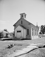
English: Front of the Corinne Methodist Episcopal Church, located at the intersection of Coronado and South 600 Streets in Corinne, Utah, United States. Built in 1870, it is listed on the National Register of Historic Places. |
|||||
| Date | ||||||
| Source | Library of Congress, Prints and Photograph Division HABS: UTAH,2-CORI,1-2 | |||||
| Author | P. Kent Fairbanks | |||||
| Permission (Reusing this file) |
|


|
This image is available from the United States Library of Congress's Prints and Photographs division
under the digital ID hhh.ut0007. This tag does not indicate the copyright status of the attached work. A normal copyright tag is still required. See Commons:Licensing.
|
File history
Click on a date/time to view the file as it appeared at that time.
| Date/Time | Thumbnail | Dimensions | User | Comment | |
|---|---|---|---|---|---|
| current | 08:50, 23 May 2009 | | 3,584 × 4,535 (1.7 MB) | Cropbot | upload cropped version, operated by User:Finavon. Summary: border cropped |
| 05:10, 23 May 2009 |  | 4,038 × 4,993 (1.94 MB) | Nyttend | {{Location|41|32|51|N|112|6|40|W}} {{Information |Description={{en|Front of the {{w|Corinne Methodist Episcopal Church}}, located at the intersection of Coronado and South 600 Streets in {{w|Corinne, Utah|Corinne}}, {{w|Utah}}, {{w|United States}}. Built |
File usage
The following pages on the English Wikipedia use this file (pages on other projects are not listed):
Global file usage
The following other wikis use this file:
- Usage on ar.wikipedia.org
- Usage on arz.wikipedia.org
- Usage on azb.wikipedia.org
- Usage on bg.wikipedia.org
- Usage on ca.wikipedia.org
- Usage on ceb.wikipedia.org
- Usage on ce.wikipedia.org
- Usage on cy.wikipedia.org
- Usage on eu.wikipedia.org
- Usage on fa.wikipedia.org
- Usage on fr.wikipedia.org
- Usage on ht.wikipedia.org
- Usage on it.wikipedia.org
- Usage on lld.wikipedia.org
- Usage on pl.wikipedia.org
- Usage on pt.wikipedia.org
- Usage on sh.wikipedia.org
- Usage on sr.wikipedia.org
- Usage on tt.wikipedia.org
- Usage on uk.wikipedia.org
- Usage on uz.wikipedia.org
- Usage on www.wikidata.org
- Usage on zh-min-nan.wikipedia.org