
File:Coord LatLong.svg

Size of this PNG preview of this SVG file: 360 × 360 pixels. Other resolutions: 240 × 240 pixels | 480 × 480 pixels | 768 × 768 pixels | 1,024 × 1,024 pixels | 2,048 × 2,048 pixels.
Original file (SVG file, nominally 360 × 360 pixels, file size: 5 KB)
| This is a file from the Wikimedia Commons. Information from its description page there is shown below. Commons is a freely licensed media file repository. You can help. |
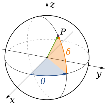
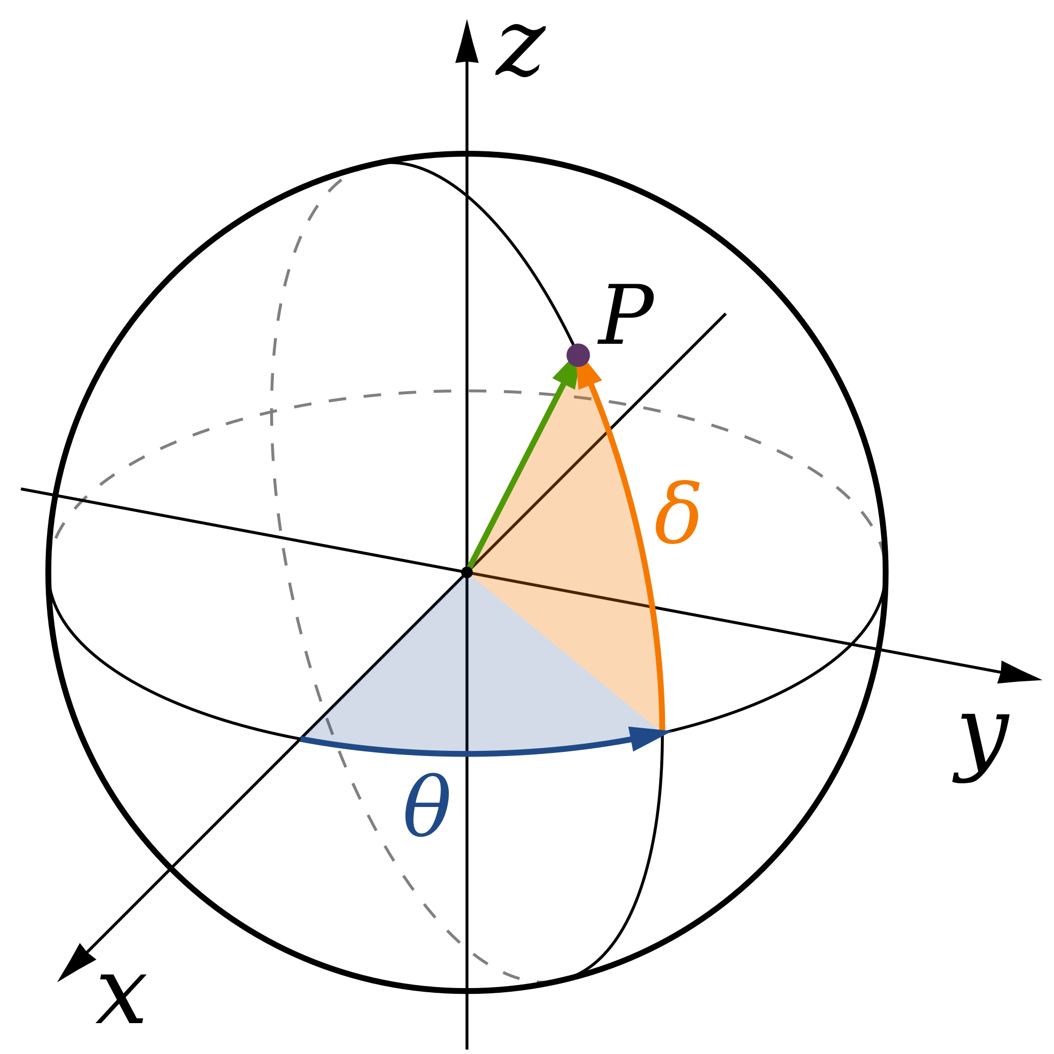
| Description | A diagram of spherical coordinates, defining a point by colatitude, φ, longitude, θ, and radius, ρ. |
| Date | (UTC) |
| Source | |
| Author |
|
.svg)
I, the copyright holder of this work, hereby publish it under the following license:
| I, the copyright holder of this work, release this work into the public domain. This applies worldwide. In some countries this may not be legally possible; if so: I grant anyone the right to use this work for any purpose, without any conditions, unless such conditions are required by law. |
Original upload log
This image is a derivative work of the following images:
- File:Spherical_Coordinates_(Colatitude,_Longitude).svg licensed with PD-self
- 2008-04-07T01:57:46Z Inductiveload 360x360 (21703 Bytes) {{Information |Description= |Source= |Date= |Author= |Permission= |other_versions= }}
- 2008-04-07T01:48:21Z Inductiveload 360x360 (21052 Bytes) {{Information |Description= |Source= |Date= |Author= |Permission= |other_versions= }}
- 2008-04-07T01:36:38Z Inductiveload 360x360 (21039 Bytes) {{Information |Description=A diagram of spherical coordinates, defining a point by colatitude, ''φ'', longitude, ''θ'', and radius, ''ρ''. |Source=self-made |Date=08/04/2008 |Author= [[User:Inductiveload|Inducti
Uploaded with derivativeFX
File history
Click on a date/time to view the file as it appeared at that time.
| Date/Time | Thumbnail | Dimensions | User | Comment | |
|---|---|---|---|---|---|
| current | 20:50, 4 September 2019 | | 360 × 360 (5 KB) | Geek3 | Orthographic projection |
| 17:52, 7 August 2009 |  | 360 × 360 (20 KB) | Andeggs~commonswiki | {{Information |Description=A diagram of spherical coordinates, defining a point by colatitude, ''φ'', longitude, ''θ'', and radius, ''ρ''. |Source=*File:Spherical_Coordinates_(Colatitude,_Longitude).svg |Date=2009-08-07 17:52 (UTC) |Au |
.svg)
File usage
The following pages on the English Wikipedia use this file (pages on other projects are not listed):
Global file usage
The following other wikis use this file:
- Usage on ar.wikipedia.org
- Usage on ba.wikipedia.org
- Usage on bg.wikipedia.org
- Usage on cy.wikipedia.org
- Usage on el.wikipedia.org
- Usage on es.wikipedia.org
- Usage on eu.wikipedia.org
- Usage on fa.wikipedia.org
- Usage on fa.wikibooks.org
- Usage on fr.wikibooks.org
- Usage on hi.wikipedia.org
- Usage on ko.wikipedia.org
- Usage on ru.wikipedia.org
- Usage on sr.wikipedia.org
- Usage on ta.wikipedia.org
- Usage on tr.wikipedia.org