
File:CookANZ.JPG
No higher resolution available.
CookANZ.JPG (237 × 154 pixels, file size: 10 KB, MIME type: image/jpeg)
| This is a file from the Wikimedia Commons. Information from its description page there is shown below. Commons is a freely licensed media file repository. You can help. |

|
This historical map image could be re-created using vector graphics as an SVG file. This has several advantages; see Commons:Media for cleanup for more information. If an SVG form of this image is available, please upload it and afterwards replace this template with
{{vector version available|new image name}}.
It is recommended to name the SVG file “CookANZ.svg”—then the template Vector version available (or Vva) does not need the new image name parameter. |


| Description |
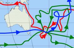
English: Map showing the three voyages of Captain James Cook proximate to Australia and New Zealand, with the first version in red, second in green, and third in blue. |
| Date | (UTC) |
| Source | |
| Author |
|
| This is a retouched picture, which means that it has been digitally altered from its original version. Modifications: Focused on Australia and NZ. The original can be viewed here: Cook Three Voyages 59.png:
|
I, the copyright holder of this work, hereby publish it under the following licenses:
This file is licensed under the Creative Commons Attribution-Share Alike 3.0 Unported license.
- You are free:
- to share – to copy, distribute and transmit the work
- to remix – to adapt the work
- Under the following conditions:
- attribution – You must give appropriate credit, provide a link to the license, and indicate if changes were made. You may do so in any reasonable manner, but not in any way that suggests the licensor endorses you or your use.
- share alike – If you remix, transform, or build upon the material, you must distribute your contributions under the same or compatible license as the original.

|
Permission is granted to copy, distribute and/or modify this document under the terms of the GNU Free Documentation License, Version 1.2 or any later version published by the Free Software Foundation; with no Invariant Sections, no Front-Cover Texts, and no Back-Cover Texts. A copy of the license is included in the section entitled GNU Free Documentation License. |
You may select the license of your choice.
Original upload log
This image is a derivative work of the following images:
- File:Cook_Three_Voyages_59.png licensed with Cc-by-sa-3.0, GFDL
- 2010-02-17T22:19:34Z AlexiusHoratius 800x401 (275844 Bytes) Made Nootka Sound landing more obvious, corrected Atlantic routes for first voyage.
- 2009-05-27T04:35:44Z AlexiusHoratius 800x401 (274764 Bytes) Made lines and arrows a bit cleaner, corrected some lines near the map's edge, background now transparent
- 2008-07-25T09:43:47Z Urdangaray 800x401 (247890 Bytes) {{Information |Description={{en|Map showing the three voyages of Captain James Cook, with the first version in red, second in green, and third in blue. The route of Cook's crew following his death is shown as a dashed blue li
Uploaded with derivativeFX
File history
Click on a date/time to view the file as it appeared at that time.
| Date/Time | Thumbnail | Dimensions | User | Comment | |
|---|---|---|---|---|---|
| current | 04:51, 24 March 2010 | | 237 × 154 (10 KB) | Tasbian | {{Information |Description={{en|Map showing the three voyages of Captain James Cook proximate to Australia and New Zealand, with the first version in red, second in green, and third in blue.}} |Source=*File:Cook_Three_Voyages_59.png |Date=2010-03-24 |
File usage
The following pages on the English Wikipedia use this file (pages on other projects are not listed):
Global file usage
The following other wikis use this file:
- Usage on it.wikipedia.org
- Usage on zh.wikipedia.org