
File:ConnLakes.jpg
No higher resolution available.
ConnLakes.jpg (213 × 330 pixels, file size: 43 KB, MIME type: image/jpeg)
| This image has source information, but it either links directly to the image or is a generic base URL, or is not an Internet source for an image that was likely found on the Internet. Source information should be provided so that the copyright status can be verified by others. It is requested that a better source be provided to make determination of the copyright information easier. Please provide a URL to an HTML page that contains this image. See Wikipedia:Citing sources#Multimedia for more information.
Please remove this template once better source information is provided. Notify the uploader with: {{subst:bsr-user|1=File:ConnLakes.jpg}} ~~~~ |
Summary[edit]
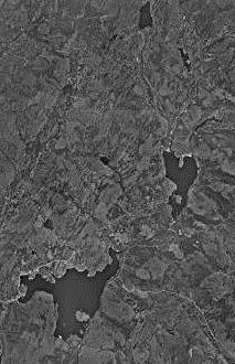
| Description |
United States Geological Survey map of the Connecticut Lakes. Approx. 188 km E of Montreal, Quebec, Canada 01 July 1975. | ||
|---|---|---|---|
| Source |
Source: [http://msrmaps.com | ||
| Date | |||
| Author |
| ||
| Permission (Reusing this file) |
See below. | ||
| Additional information | 45°5′37″N 71°14′52″W / 45.09361°N 71.24778°W |
Licensing[edit]
| This image is a work of a United States Geological Survey employee, taken or made as part of that person's official duties. As a work of the United States Government, the image is in the public domain in the US. For more information, see the USGS copyright policy. See Wikipedia:Public domain and Wikipedia:Copyrights for more details. |
File history
Click on a date/time to view the file as it appeared at that time.
| Date/Time | Thumbnail | Dimensions | User | Comment | |
|---|---|---|---|---|---|
| current | 23:40, 24 February 2012 | | 213 × 330 (43 KB) | Zfish118 (talk | contribs) | United States Geological Survey map of the Connecticut Lake. Approx. 188 km E of Montreal, Quebec, Canada 01 July 1975. Source: [http://msrmaps.com|MSR Research Maps] {{coord|45|5|37|N|71|14|52|W|type:waterbody_region:US}} |
You cannot overwrite this file.
File usage
The following pages on the English Wikipedia use this file (pages on other projects are not listed):