
File:Cliffs at West Runton Beach - geograph.org.uk - 794779.jpg
No higher resolution available.
Cliffs_at_West_Runton_Beach_-_geograph.org.uk_-_794779.jpg (640 × 480 pixels, file size: 197 KB, MIME type: image/jpeg)
| This is a file from the Wikimedia Commons. Information from its description page there is shown below. Commons is a freely licensed media file repository. You can help. |
Summary
| Description |
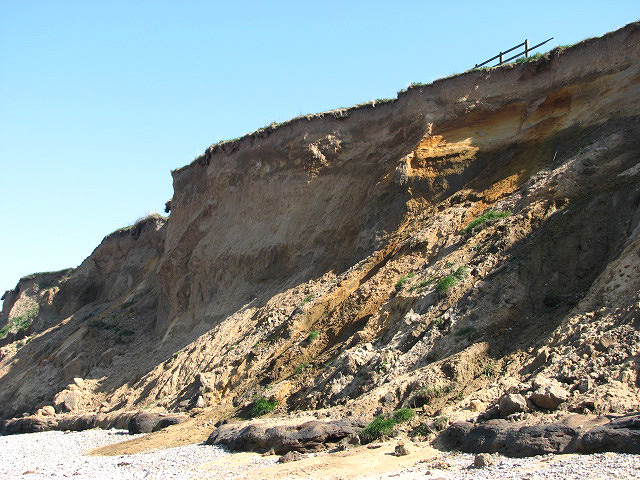
English: Cliffs at West Runton Beach The dark layer at the cliff base is the West Runton Freshwater Bed.
The West Runton Freshwater Bed was formed by mud deposited by a river that once used to flow here about 600,000 to 700,000 years ago, long before the onset of the Ice Ages. Its main outcrop lies to the east of West Runton Gap where it forms a dark bed of up to two metres in thickness at the cliff base. This layer is very rich in fossil remains of plants and trees, molluscs, fish, amphibians, birds and large and small mammals - the skeleton of an elephant (Mammuthus trogontherii) was discovered near here in December 1990. http://www.museums.norfolk.gov.uk/default.asp?Document=400.500.050x1 |
| Date | |
| Source | From geograph.org.uk |
| Author | Evelyn Simak |
| Attribution (required by the license) | Evelyn Simak / Cliffs at West Runton Beach / |
| Camera location | | View this and other nearby images on: OpenStreetMap |
|---|
_heading:135.00&language=en)
| Object location | | View this and other nearby images on: OpenStreetMap |
|---|
_heading:135.00&language=en)
Licensing

|
This image was taken from the Geograph project collection. See this photograph's page on the Geograph website for the photographer's contact details. The copyright on this image is owned by Evelyn Simak and is licensed for reuse under the Creative Commons Attribution-ShareAlike 2.0 license.
|
This file is licensed under the Creative Commons Attribution-Share Alike 2.0 Generic license.
Attribution: Evelyn Simak
- You are free:
- to share – to copy, distribute and transmit the work
- to remix – to adapt the work
- Under the following conditions:
- attribution – You must give appropriate credit, provide a link to the license, and indicate if changes were made. You may do so in any reasonable manner, but not in any way that suggests the licensor endorses you or your use.
- share alike – If you remix, transform, or build upon the material, you must distribute your contributions under the same or compatible license as the original.
File history
Click on a date/time to view the file as it appeared at that time.
| Date/Time | Thumbnail | Dimensions | User | Comment | |
|---|---|---|---|---|---|
| current | 04:26, 20 February 2011 | | 640 × 480 (197 KB) | GeographBot | == {{int:filedesc}} == {{Information |description={{en|1=Cliffs at West Runton Beach The dark layer at the cliff base is the West Runton Freshwater Bed. The West Runton Freshwater Bed was formed by mud deposited by a river that once used to flow here a |
File usage
The following pages on the English Wikipedia use this file (pages on other projects are not listed):