
File:Clark's 1867 Map Nichol's Farms.JPG

Original file (2,093 × 2,574 pixels, file size: 4.21 MB, MIME type: image/jpeg)
Summary[edit]
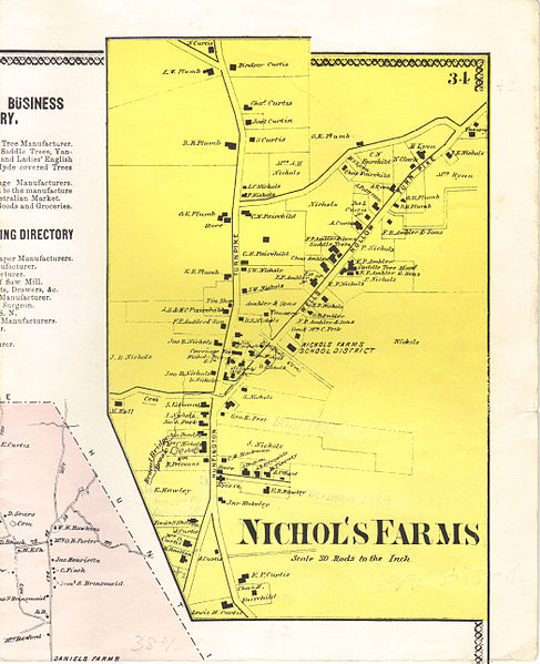
| Description |
English: Map Trumbull, Connecticut 1867 |
|---|---|
| Source |
(Original text : Atlas of New York and Vicinity, Plate 34, "Town of Trumbull, Fairfield Co. Conn") |
| Date |
1867 |
| Author |
F.W. Beers, A.D. Ellis & G.C. Soule. Original uploader was Tomticker5 at en.wikipedia |
| Permission (Reusing this file) |
PD-US.
|
Licensing[edit]
| This work is in the public domain in the United States because it was published (or registered with the U.S. Copyright Office) before January 1, 1929. |
 | This file is a candidate to be copied to Wikimedia Commons.
Any user may perform this transfer; refer to Wikipedia:Moving files to Commons for details. If this file has problems with attribution, copyright, or is otherwise ineligible for Commons, then remove this tag and DO NOT transfer it; repeat violators may be blocked from editing. Other Instructions
| ||
| |||
File history
Click on a date/time to view the file as it appeared at that time.
| Date/Time | Thumbnail | Dimensions | User | Comment | |
|---|---|---|---|---|---|
| current | 15:35, 9 October 2010 | | 2,093 × 2,574 (4.21 MB) | Tomticker5 (talk | contribs) | {{Information |Description={{en|Map Trumbull, Connecticut 1867}} |Source=(Original text : ''Atlas of New York and Vicinity, Plate 34, "Town of Trumbull, Fairfield Co. Conn"'')</br>Transferred from [http://en.wikipedia.org en.wikipedia] |Date=1867<br/> ({{ |
You cannot overwrite this file.