
File:Church Hall - blue plaque - geograph.org.uk - 893912.jpg
No higher resolution available.
Church_Hall_-_blue_plaque_-_geograph.org.uk_-_893912.jpg (640 × 480 pixels, file size: 103 KB, MIME type: image/jpeg)
| This is a file from the Wikimedia Commons. Information from its description page there is shown below. Commons is a freely licensed media file repository. You can help. |
Summary
| Description |
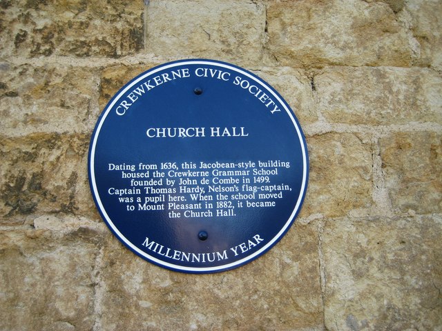
English: Church Hall, Crewkerne. There is always confusion over Dorset's two famous men called Thomas Hardy. This plaque mentions Thomas Masterman Hardy (or "Kiss me Hardy") born in Dorset at Kingston Russell, moving to Portesham in 1769 and going to sea in 1781 to become a close friend of Admiral Nelson - Hardy was at his side when Nelson was dying in battle. Hardy's Monument on the hill above Portesham is in his memory. See also images Church Hall Crewkerne - geograph.org.uk - 897115.jpg and Hardy's Monument - geograph.org.uk - 931885.jpg, and Wikipedia articles Sir Thomas Hardy, 1st Baronet and Crewkerne Grammar School. |
| Date | |
| Source | From geograph.org.uk |
| Author | Sarah Smith |
| Attribution (required by the license) | Sarah Smith / Church Hall - blue plaque / |
| Camera location | | View this and other nearby images on: OpenStreetMap |
|---|
_heading:292.00&language=en)
| Object location | | View this and other nearby images on: OpenStreetMap |
|---|
_heading:292.00&language=en)
Licensing

|
This image was taken from the Geograph project collection. See this photograph's page on the Geograph website for the photographer's contact details. The copyright on this image is owned by Sarah Smith and is licensed for reuse under the Creative Commons Attribution-ShareAlike 2.0 license.
|
This file is licensed under the Creative Commons Attribution-Share Alike 2.0 Generic license.
Attribution: Sarah Smith
- You are free:
- to share – to copy, distribute and transmit the work
- to remix – to adapt the work
- Under the following conditions:
- attribution – You must give appropriate credit, provide a link to the license, and indicate if changes were made. You may do so in any reasonable manner, but not in any way that suggests the licensor endorses you or your use.
- share alike – If you remix, transform, or build upon the material, you must distribute your contributions under the same or compatible license as the original.
File history
Click on a date/time to view the file as it appeared at that time.
| Date/Time | Thumbnail | Dimensions | User | Comment | |
|---|---|---|---|---|---|
| current | 15:33, 21 February 2011 | | 640 × 480 (103 KB) | GeographBot | == {{int:filedesc}} == {{Information |description={{en|1=Church Hall - blue plaque There is always confusion over Dorset's two famous men called Thomas Hardy. This plaque mentions Thomas Masterman Hardy (or "Kiss me Hardy") born in Dorset at Kingston Rus |
File usage
The following pages on the English Wikipedia use this file (pages on other projects are not listed):
Global file usage
The following other wikis use this file:
- Usage on it.wikipedia.org
- Usage on ja.wikipedia.org