
File:Chimney Rock Trail Point Reyes December 2016 panorama 1.jpg

Size of this preview: 800 × 516 pixels. Other resolutions: 320 × 206 pixels | 640 × 412 pixels | 1,024 × 660 pixels | 1,280 × 825 pixels | 2,560 × 1,650 pixels | 9,000 × 5,800 pixels.
Original file (9,000 × 5,800 pixels, file size: 19.19 MB, MIME type: image/jpeg)
| This is a file from the Wikimedia Commons. Information from its description page there is shown below. Commons is a freely licensed media file repository. You can help. |
Summary
| Description |
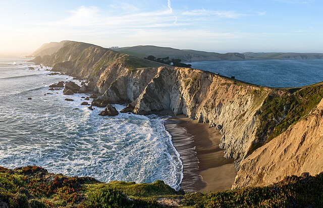
Three-segment panorama of Point Reyes headlands from Chimney Rock Trail, Point Reyes National Seashore, California. Français : Promontoires du Point Reyes National Seashore, une aire protégée américaine située sur les bords de l'océan Pacifique, en Californie.
Magyar: A Point Reyes nemzeti tengerpart földnyelve (Kalifornia)
Македонски: ’Ртот Поинт Рејес во Калифорнија, САД.
বাংলা: পয়েন্ট রেইস জাতীয় সমুদ্রতটের অন্তরীপ, ক্যালিফোর্নিয়া।
Čeština: Pohled na pobřeží v přírodní rezervaci Point Reyes National Seashore na mysu Point Reyes v Kalifornii. |
| Date | |
| Source | Own work |
| Author | King of Hearts |
| Other versions |

.jpg)
| Camera location | | View this and other nearby images on: OpenStreetMap |
|---|
|
This image was selected as picture of the day on Wikimedia Commons for 3 December 2020. It was captioned as follows: Other languages:
Čeština: Pohled na pobřeží v přírodní rezervaci Point Reyes National Seashore na mysu Point Reyes v Kalifornii. Français : Promontoires du Point Reyes National Seashore, une aire protégée américaine située sur les bords de l'océan Pacifique, en Californie. Magyar: A Point Reyes nemzeti tengerpart földnyelve (Kalifornia) Македонски: ’Ртот Поинт Рејес во Калифорнија, САД. বাংলা : পয়েন্ট রেইস জাতীয় সমুদ্রতটের অন্তরীপ, ক্যালিফোর্নিয়া। العربية : أحد رؤووس ساحل بوينت ريس الوطني في كاليفورنيا. |
Licensing
I, the copyright holder of this work, hereby publish it under the following license:
This file is licensed under the Creative Commons Attribution-Share Alike 4.0 International license.
- You are free:
- to share – to copy, distribute and transmit the work
- to remix – to adapt the work
- Under the following conditions:
- attribution – You must give appropriate credit, provide a link to the license, and indicate if changes were made. You may do so in any reasonable manner, but not in any way that suggests the licensor endorses you or your use.
- share alike – If you remix, transform, or build upon the material, you must distribute your contributions under the same or compatible license as the original.
File history
Click on a date/time to view the file as it appeared at that time.
| Date/Time | Thumbnail | Dimensions | User | Comment | |
|---|---|---|---|---|---|
| current | 05:52, 8 December 2016 | | 9,000 × 5,800 (19.19 MB) | King of Hearts | VicuñaUploader 1.23 |
File usage
The following pages on the English Wikipedia use this file (pages on other projects are not listed):
Global file usage
The following other wikis use this file:
- Usage on av.wikipedia.org
- Usage on azb.wikipedia.org
- Usage on be-tarask.wikipedia.org
- Usage on bn.wikipedia.org
- Usage on da.wikipedia.org
- Usage on de.wikipedia.org
- Usage on en.wikivoyage.org
- Usage on es.wikipedia.org
- Usage on fa.wikipedia.org
- Usage on fr.wikipedia.org
- Usage on he.wikivoyage.org
- Usage on hu.wikipedia.org
- Usage on hy.wikipedia.org
- Usage on it.wikipedia.org
- Usage on ja.wikipedia.org
- Usage on ka.wikipedia.org
- Usage on ko.wikipedia.org
- Usage on lez.wikipedia.org
- Usage on pt.wikipedia.org
- Usage on ru.wikipedia.org
- Usage on ru.wikinews.org
- Usage on te.wikipedia.org
- Usage on th.wikipedia.org
- Usage on tt.wikipedia.org
- Usage on vep.wikipedia.org
- Usage on vi.wikipedia.org
- Usage on www.wikidata.org
- Usage on zh.wikipedia.org