
File:Chertified fossiliferous limestone (Ft. Payne Limestone, Lower Mississippian; Lake Cumberland, Kentucky, USA) 2 (30748692874).jpg

Original file (3,223 × 1,736 pixels, file size: 3.57 MB, MIME type: image/jpeg)
| This is a file from the Wikimedia Commons. Information from its description page there is shown below. Commons is a freely licensed media file repository. You can help. |
_2_(30748692874).jpg)
Summary
| Description |
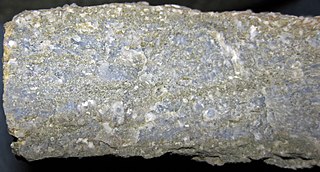
Chertified fossiliferous limestone from the Mississippian of Kentucky, USA. (cross-section view) The Ft. Payne Formation of southern Kentucky is richly fossiliferous and is dominated by crinoids. Crinoids ("sea lilies") are sessile, benthic, filter-feeding, marine invertebrates that were abundant in Paleozoic oceans. The group nearly went extinct at the Permian-Triassic mass extinction 251 million years ago. Crinoids are not common in modern oceans - they are usually deep-water forms now, but some shallow-water forms also exist today. A crinoid is essentially a starfish on a stick. The stick, or stem, lifts the organism to a moderately high tier above the seafloor, which is conducive to non-competitive filter feeding. The flower-like "head" of the crinoid consists of numerous cemented calcite plates that surround the digestive system and other soft parts. The arms are feather-like and are the structures that engage in filter-feeding. In the fossil record, crinoid stems are common, whereas crinoid heads are uncommon to rare, because they disaggregate quickly after death. Individual pieces of a crinoid stem are called columnals - they are usually somewhat shaped like poker chips. Each columnal is composed of a single crystal of calcite (CaCO3 - calcium carbonate). The fossiliferous limestone shown above is dominated by crinoid stem columnals. Such crinoid-rich limestones are called "encrinites". The slightly bluish-gray material is chert - the original limestone has been mostly chertified. Classification: Animalia, Echinodermata, Crinoidea Stratigraphy: packstone buildup in the Ft. Payne Formation, Osagean Stage, upper Lower Mississippian Locality: Cave Springs South Outcrop - lakeside outcrop, north-central Lake Cumberland, just south of the intersection of the Wolf Creek/Caney Creek arm of Lake Cumberland with Lake Cumberland proper, Russell County, southern Kentucky, USA (vicinity of 36° 56' 26.59" North latitude, 85° 00' 25.44" West longitude) See info. at: <a href="https://en.wikipedia.org/wiki/Encrinite" rel="nofollow">en.wikipedia.org/wiki/Encrinite</a> |
| Date | |
| Source | Chertified fossiliferous limestone (Ft. Payne Limestone, Lower Mississippian; Lake Cumberland, Kentucky, USA) 2 |
| Author | James St. John |
Licensing
- You are free:
- to share – to copy, distribute and transmit the work
- to remix – to adapt the work
- Under the following conditions:
- attribution – You must give appropriate credit, provide a link to the license, and indicate if changes were made. You may do so in any reasonable manner, but not in any way that suggests the licensor endorses you or your use.
| This image was originally posted to Flickr by James St. John at https://flickr.com/photos/47445767@N05/30748692874 (archive). It was reviewed on 12 October 2019 by FlickreviewR 2 and was confirmed to be licensed under the terms of the cc-by-2.0. |
File history
Click on a date/time to view the file as it appeared at that time.
| Date/Time | Thumbnail | Dimensions | User | Comment | |
|---|---|---|---|---|---|
| current | 04:02, 12 October 2019 | | 3,223 × 1,736 (3.57 MB) | Ser Amantio di Nicolao | Transferred from Flickr via #flickr2commons |
_2_(30748692874).jpg)