
File:Charles Mill Lake.jpg

Size of this preview: 800 × 594 pixels. Other resolutions: 320 × 238 pixels | 640 × 475 pixels | 1,024 × 760 pixels | 1,280 × 950 pixels | 2,080 × 1,544 pixels.
Original file (2,080 × 1,544 pixels, file size: 527 KB, MIME type: image/jpeg)
| This is a file from the Wikimedia Commons. Information from its description page there is shown below. Commons is a freely licensed media file repository. You can help. |
Summary
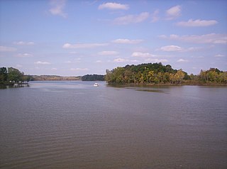
| Description | A view of Charles Mill Lake near Mifflin, Ohio was taken from over the Ohio 430 bridge looking northwest. Photo is taken in Ashland County, Ohio, but virtually everything in the photo is in Richland County. | ||||||||
| Date | |||||||||
| Source | Self-photographed | ||||||||
| Author | User:OHWiki | ||||||||
| Permission (Reusing this file) |
I, the copyright holder of this work, hereby publish it under the following licenses:
This file is licensed under the Creative Commons Attribution-Share Alike 2.5 Generic license.
You may select the license of your choice. |

| Camera location | | View this and other nearby images on: OpenStreetMap |
|---|
File history
Click on a date/time to view the file as it appeared at that time.
| Date/Time | Thumbnail | Dimensions | User | Comment | |
|---|---|---|---|---|---|
| current | 19:09, 6 October 2007 | | 2,080 × 1,544 (527 KB) | OHWiki~commonswiki | {{Information |Description=This photograph of Charles Mill Lake near Mifflin, Ohio was taken over the Ohio 430 bridge with a view from the south looking north on 6 October 2007 by Use |
File usage
The following pages on the English Wikipedia use this file (pages on other projects are not listed):
Global file usage
The following other wikis use this file:
- Usage on de.wikipedia.org
- Usage on www.wikidata.org