
File:Central line & London map.svg

Size of this PNG preview of this SVG file: 800 × 459 pixels. Other resolutions: 320 × 184 pixels | 640 × 368 pixels | 1,024 × 588 pixels | 1,280 × 735 pixels | 2,560 × 1,470 pixels | 895 × 514 pixels.
Original file (SVG file, nominally 895 × 514 pixels, file size: 1.13 MB)
| This is a file from the Wikimedia Commons. Information from its description page there is shown below. Commons is a freely licensed media file repository. You can help. |
Summary
| Description |
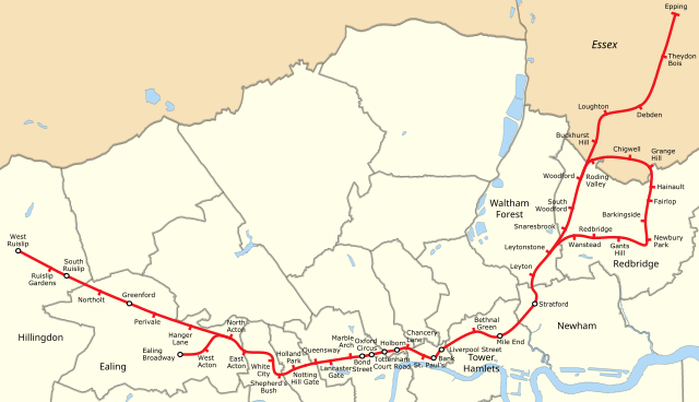
English: The route of the Central line through the Greater London Boroughs. NB DRAFT ONLY!! |
| Date | |
| Source | File:Central Line.svg and File:Greater London UK district map (blank).svg |
| Author | As detailed on those pages |
.svg)
Licensing
This file is licensed under the Creative Commons Attribution-Share Alike 3.0 Unported license.
- You are free:
- to share – to copy, distribute and transmit the work
- to remix – to adapt the work
- Under the following conditions:
- attribution – You must give appropriate credit, provide a link to the license, and indicate if changes were made. You may do so in any reasonable manner, but not in any way that suggests the licensor endorses you or your use.
- share alike – If you remix, transform, or build upon the material, you must distribute your contributions under the same or compatible license as the original.
File history
Click on a date/time to view the file as it appeared at that time.
| Date/Time | Thumbnail | Dimensions | User | Comment | |
|---|---|---|---|---|---|
| current | 16:58, 26 May 2013 | | 895 × 514 (1.13 MB) | Edgepedia | Add borough names |
| 16:38, 26 May 2013 |  | 891 × 514 (1.13 MB) | Edgepedia | User created page with UploadWizard |
File usage
The following pages on the English Wikipedia use this file (pages on other projects are not listed):
Global file usage
The following other wikis use this file:
- Usage on ar.wikipedia.org
- Usage on cs.wikipedia.org
- Usage on da.wikipedia.org
- Usage on de.wikipedia.org
- Usage on ko.wikipedia.org
- Usage on nl.wikipedia.org
- Usage on www.wikidata.org
- Usage on yi.wikipedia.org
- Usage on zh-min-nan.wikipedia.org
- Usage on zh.wikipedia.org