
File:Central African Republic Map.jpg

Size of this preview: 573 × 600 pixels. Other resolutions: 229 × 240 pixels | 459 × 480 pixels | 972 × 1,017 pixels.
Original file (972 × 1,017 pixels, file size: 554 KB, MIME type: image/jpeg)
| This is a file from the Wikimedia Commons. Information from its description page there is shown below. Commons is a freely licensed media file repository. You can help. |
| Description |
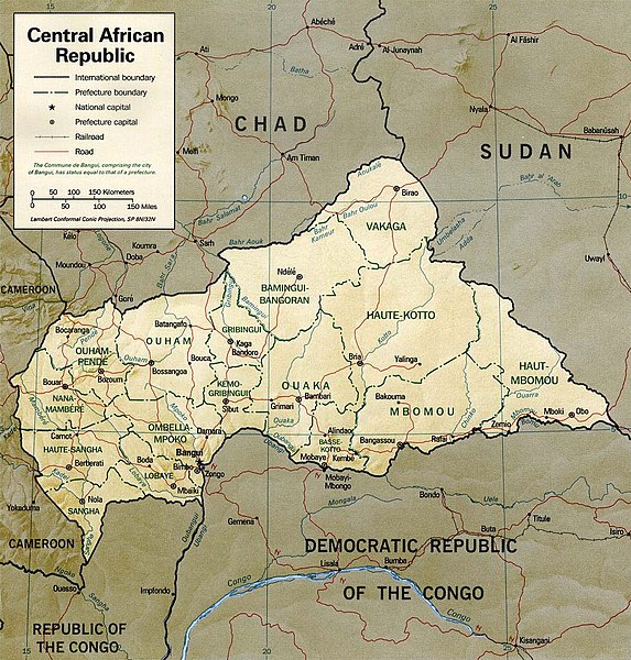
English: Shaded relief map of the Central African Republic.
|
|||
| Date | ||||
| Source | [1] from the Perry-Castañeda Library Map Collection. | |||
| Author | CIA | |||
| Permission (Reusing this file) |
|

![[1]](http://www.lib.utexas.edu/maps/africa/cen_african_rep_rel01.jpg)
File history
Click on a date/time to view the file as it appeared at that time.
| Date/Time | Thumbnail | Dimensions | User | Comment | |
|---|---|---|---|---|---|
| current | 19:15, 5 July 2011 | | 972 × 1,017 (554 KB) | Ras67 | cropped and slightly leveled |
| 11:53, 21 February 2006 |  | 1,032 × 1,076 (261 KB) | Lupo | Shaded relief map of the Central African Republic. Source: [http://www.lib.utexas.edu/maps/africa/cen_african_rep_rel01.jpg] from the [http://www.lib.utexas.edu/maps/central_african_republic.html Perry-Castañeda Library Map Collection]. {{PD-USGov- |
File usage
The following pages on the English Wikipedia use this file (pages on other projects are not listed):
Global file usage
The following other wikis use this file:
- Usage on ca.wikipedia.org
- Usage on fa.wikipedia.org
- Usage on fr.wikipedia.org
- Usage on it.wikipedia.org
- Usage on ka.wikipedia.org
- Usage on lfn.wikipedia.org
- Usage on lt.wikipedia.org
- Usage on mdf.wikipedia.org
- Usage on mk.wikipedia.org
- Usage on nl.wikipedia.org
- Usage on pl.wikipedia.org
- Usage on ru.wikipedia.org
- Usage on sn.wikipedia.org
- Usage on su.wikipedia.org
- Usage on tt.wikipedia.org
- Usage on uk.wikipedia.org
- Usage on vec.wikipedia.org
- Usage on www.wikidata.org
- Usage on zh.wikipedia.org