
File:Cederberg LM topographic map.svg

Size of this PNG preview of this SVG file: 614 × 600 pixels. Other resolutions: 246 × 240 pixels | 491 × 480 pixels | 786 × 768 pixels | 1,049 × 1,024 pixels | 2,097 × 2,048 pixels | 1,113 × 1,087 pixels.
Original file (SVG file, nominally 1,113 × 1,087 pixels, file size: 9.7 MB)
| This is a file from the Wikimedia Commons. Information from its description page there is shown below. Commons is a freely licensed media file repository. You can help. |
Summary
| Description |
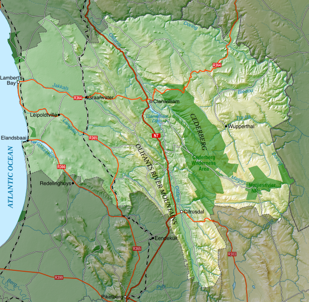
English: Topographic map of the Cederberg Local Municipality in South Africa. |
|||
| Date | ||||
| Source | Own work | |||
| Author | Htonl | |||
| Permission (Reusing this file) |
I, the copyright holder of this work, hereby publish it under the following license: This file is licensed under the Creative Commons Attribution-Share Alike 4.0 International and 3.0 Unported license.
|
|||
| SVG development |
File history
Click on a date/time to view the file as it appeared at that time.
| Date/Time | Thumbnail | Dimensions | User | Comment | |
|---|---|---|---|---|---|
| current | 14:14, 29 May 2021 | | 1,113 × 1,087 (9.7 MB) | Htonl | Restore previous changes + minor roads |
| 13:42, 29 May 2021 |  | 1,113 × 1,087 (9.71 MB) | Htonl | Add minor roads | |
| 10:00, 20 November 2020 |  | 1,113 × 1,087 (9.46 MB) | Htonl | stop the validator from complaining about aria-label tags | |
| 09:24, 20 November 2020 |  | 1,113 × 1,087 (9.46 MB) | Htonl | correct N2 label to N7 | |
| 07:43, 18 June 2019 |  | 1,113 × 1,087 (9.46 MB) | Htonl | Add Wupperthal | |
| 21:49, 17 June 2019 |  | 1,113 × 1,087 (9.45 MB) | Htonl | {{Information |Description ={{en|1=Topographic map of the Cederberg Local Municipality in South Africa.}} |Source ={{own}} |Author =Htonl |Date =2019-06-17 |Permission ={{self|cc-by-sa-3.0}}{{ODbL OpenStreetMap}} |other_versions = }} Category:Maps of local municipalities of the Western Cape |
File usage
The following pages on the English Wikipedia use this file (pages on other projects are not listed):
Global file usage
The following other wikis use this file:
- Usage on de.wikipedia.org
- Usage on www.wikidata.org