File:Cavite-Tagaytay-Batangas-Expressway map 20210809.jpg

Page contents not supported in other languages.
This is a file from the Wikimedia Commons
From Wikipedia, the free encyclopedia

Original file(2,560 × 1,792 pixels, file size: 3.35 MB, MIME type: image/jpeg)

Summary

Description
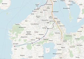
English: Map showing the location of Cavite–Tagaytay–Batangas Expressway, selected components of the Philippine expressway network, and nearby towns and cities
Map legend
 
Proposed highway alignment
 
Proposed interchanges
 
Approximate location of interchange with CALAX
 
Tagaytay-Nasugbu Highway
 
SLEX and Skyway
 
CAVITEX
 
CALAX
 
Label for town or city
Date
  • October 2017 (Alignment and proposed interchanges, based on Cavite–Tagaytay–Batangas Expressway. Department of Public Works and Highways. Archived from the original on October 3, 2017. Retrieved on August 9, 2021.)
  • August 9, 2020 (OpenStreetMap overlay and selected highways)
  • August 9, 2021 (Other map labels)
Source
Creator
  • Map overlay and selected highways: OpenStreetMap contributors
  • Alignment and proposed interchanges: Information supplied from the Department of Public Works and Highways
  • Other labels: Own work
Permission
(Reusing this file)
OpenStreetMap overlay and selected highways
This work contains information from OpenStreetMap, which is made available under the Open Database License (ODbL).

The ODbL does not require any particular license for maps produced from ODbL data. Prior to 1 August 2020, map tiles produced by the OpenStreetMap Foundation were licensed under the CC-BY-SA-2.0 license. Maps produced by other people may be subject to other licences.

Alignment and proposed interchanges
Public domain This work is in the public domain in the Philippines and possibly other jurisdictions because it is a work created by an officer or employee of the Government of the Philippines or any of its subdivisions and instrumentalities, including government-owned and/or controlled corporations, as part of their regularly prescribed official duties; consequently, any work is ineligible for copyright under the terms of Part IV, Chapter I, Section 171.11 and Part IV, Chapter IV, Section 176 of Republic Act No. 8293 and Republic Act No. 10372, as amended, unless otherwise noted. However, in some instances, the use of this work in the Philippines or elsewhere may be regulated by this law or other laws.

English  español  日本語  Tagalog  简体中文  繁體中文  +/−

Coat of arms of the Philippines
Other map labels
I, the copyright holder of this work, hereby publish it under the following licenses:
WTFPL
Permission is granted to do what the fuck you want to with this document under the terms of the WTF Public License, Version 2.
WTF Public LicenseWTFPLfalsefalsehttp://www.wtfpl.net/about/
Creative Commons CC-Zero This file is made available under the Creative Commons CC0 1.0 Universal Public Domain Dedication.
The person who associated a work with this deed has dedicated the work to the public domain by waiving all of their rights to the work worldwide under copyright law, including all related and neighboring rights, to the extent allowed by law. You can copy, modify, distribute and perform the work, even for commercial purposes, all without asking permission.

You may select the license of your choice.

Captions

Add a one-line explanation of what this file represents

Items portrayed in this file

depicts

image/jpeg

e8ea8c1a499925d0ebdc7947a0c699ce75fc05e7

3,515,768 byte

1,792 pixel

2,560 pixel

File history

Click on a date/time to view the file as it appeared at that time.

Date/TimeThumbnailDimensionsUserComment
current13:24, 9 August 2021Thumbnail for version as of 13:24, 9 August 20212,560 × 1,792 (3.35 MB)Ianlopez1115{{Map |Description={{en|1=Map showing the location of Cavite–Tagaytay–Batangas Expressway, selected components of the Philippine expressway network, and nearby towns and cities}} |Legend= {{Legend|#89a3ca|Proposed highway alignment}} {{Legend|#ff0000|Proposed interchanges|css=border:4px solid #000000}} {{Legend|#7030a0|Approximate location of interchange with CALAX|css=border:4px solid #000000}} {{Legend|#94d394|Tagaytay-Nasugbu Highway}} {{Legend|#fbd71a|SLEX and Skyway|css=border:4px solid...
No pages on the English Wikipedia use this file (pages on other projects are not listed).

Metadata