
File:Caucasus 1060n map de.png
Size of this preview: 771 × 599 pixels. Other resolutions: 309 × 240 pixels | 618 × 480 pixels | 988 × 768 pixels | 1,280 × 995 pixels | 2,560 × 1,990 pixels | 2,990 × 2,324 pixels.
Original file (2,990 × 2,324 pixels, file size: 3.57 MB, MIME type: image/png)
| This is a file from the Wikimedia Commons. Information from its description page there is shown below. Commons is a freely licensed media file repository. You can help. |
Summary
| Description |
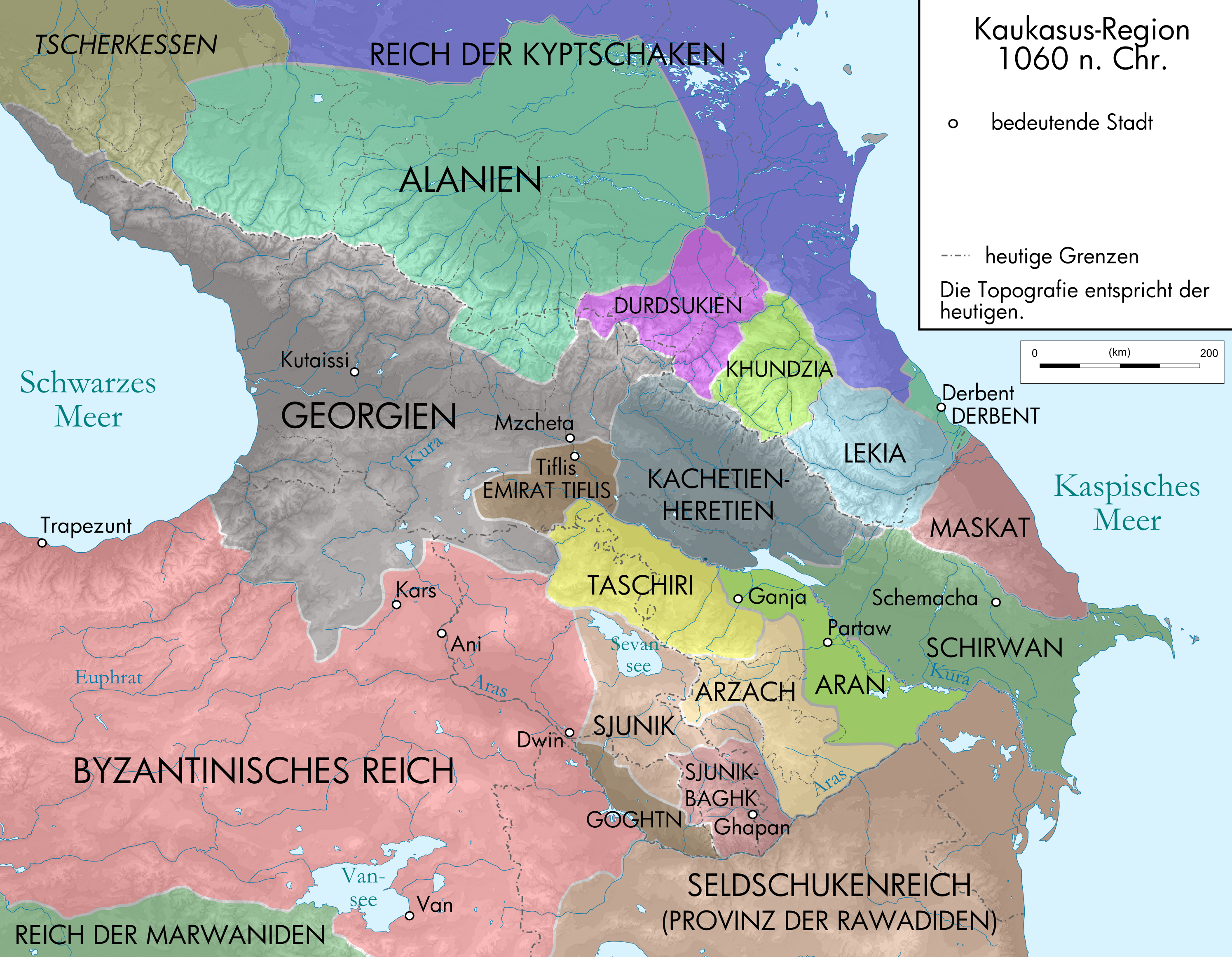
English: Map of Caucasus Region around 1060 AD in German.
Deutsch: Kaukasus-Region um 1060 n. Chr. Quellen sind Putzger historischer Weltatlas Ausgabe 2005, Heinz Fähnrich: Geschichte Georgiens von den Anfängen bis zur Mongolenherrschaft. Shaker, Aachen 1993, ISBN 3-86111-683-9, File:Shaddadid.gif , File:Jorgat harasm.gif , File:Arcax.jpg , File:Geor david.gif , File:Arcax.jpg , http://www.armenica.org/cgi-bin/armenica.cgi?178711717323498=1=3==Armenia==1=3=AAA , File:Alania_10_12.png bzw. die dort genannten Quellen |
| Date | |
| Source | |
| Author |
|
| Other versions |
|


Licensing
I, the copyright holder of this work, hereby publish it under the following licenses:
This file is licensed under the Creative Commons Attribution-Share Alike 3.0 Unported license.
- You are free:
- to share – to copy, distribute and transmit the work
- to remix – to adapt the work
- Under the following conditions:
- attribution – You must give appropriate credit, provide a link to the license, and indicate if changes were made. You may do so in any reasonable manner, but not in any way that suggests the licensor endorses you or your use.
- share alike – If you remix, transform, or build upon the material, you must distribute your contributions under the same or compatible license as the original.

|
Permission is granted to copy, distribute and/or modify this document under the terms of the GNU Free Documentation License, Version 1.2 or any later version published by the Free Software Foundation; with no Invariant Sections, no Front-Cover Texts, and no Back-Cover Texts. A copy of the license is included in the section entitled GNU Free Documentation License. |
You may select the license of your choice.
File history
Click on a date/time to view the file as it appeared at that time.
| Date/Time | Thumbnail | Dimensions | User | Comment | |
|---|---|---|---|---|---|
| current | 15:19, 2 November 2021 | | 2,990 × 2,324 (3.57 MB) | NordNordWest | Reverted to version as of 10:30, 29 October 2021 (UTC), see discussion page |
| 14:56, 29 October 2021 |  | 3,000 × 2,332 (3.54 MB) | Ruthven | Reverted to version as of 17:57, 28 October 2021 (UTC) | |
| 10:30, 29 October 2021 |  | 2,990 × 2,324 (3.57 MB) | Don-kun | Reverted to version as of 08:21, 9 February 2021 (UTC) thats not on you to decide. also Tsutsiev agrees on this (http://www.iriston.com/books/cuciev_-_etno_atlas/maps/map46.jpg) and you reinserted several error. make your own map when you disagree with this | |
| 17:57, 28 October 2021 |  | 3,000 × 2,332 (3.54 MB) | Ercwlff | Reverted to version as of 20:31, 5 February 2021 (UTC) Ruslan Suleymanovich Bzarov is not a credible source | |
| 08:21, 9 February 2021 |  | 2,990 × 2,324 (3.57 MB) | Don-kun | Reverted to version as of 18:32, 20 February 2010 (UTC) what was that for? the map was changed according to the new sources added, reverting is contradicting the sources | |
| 20:31, 5 February 2021 |  | 3,000 × 2,332 (3.54 MB) | Ercwlff | Reverted to version as of 15:11, 22 June 2009 (UTC) | |
| 18:32, 20 February 2010 |  | 2,990 × 2,324 (3.57 MB) | Don-kun | ? | |
| 17:42, 20 February 2010 |  | 1,155 × 898 (4.49 MB) | Don-kun | corrections, new sources | |
| 15:11, 22 June 2009 |  | 3,000 × 2,332 (3.54 MB) | Don-kun | {{Information |Description={{en|1=Map of Caucasus Region around 1060 AD in German.}} {{de|1=Kaukasus-Region um 1060 n. Chr. Quellen sind Putzger historischer Weltatlas Ausgabe 2005, Heinz Fähnrich: ''Geschichte Georgiens von den Anfängen bis zur Mongole |
File usage
The following pages on the English Wikipedia use this file (pages on other projects are not listed):
Global file usage
The following other wikis use this file:
- Usage on als.wikipedia.org
- Usage on az.wikipedia.org
- Usage on da.wikipedia.org
- Usage on de.wikipedia.org
- Usage on es.wikipedia.org
- Usage on fr.wikipedia.org
- Usage on hy.wikipedia.org
- Usage on inh.wikipedia.org
- Usage on krc.wikipedia.org
- Usage on mt.wikipedia.org
- Usage on nl.wikipedia.org
- Usage on pl.wikipedia.org
- Usage on ru.wikipedia.org
- Usage on tg.wikipedia.org
- Usage on tr.wikipedia.org
- Usage on uk.wikipedia.org