File:Castaic Fort Tejon Rancho Castac Castec San Jose Public Library CALIFORNIA ROOM 1862 United States Survey.jpg

Page contents not supported in other languages.
This is a file from the Wikimedia Commons
From Wikipedia, the free encyclopedia

Original file(5,012 × 5,012 pixels, file size: 8.93 MB, MIME type: image/jpeg)

Summary

Description
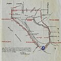
English: Castaic Fort Tejon Rancho Castac Castec San Jose Public Library CALIFORNIA ROOM 1862 United States Survey
Date
Source

SAN JOSE PUBLIC LIBRARY CALIFORNIA ROOM

https://digitalcollections.sjlibrary.org/digital/collection/sjplmaps/id/140

Transcript PLAT of the RANCHO CASTAC finally confirmed to Jose Maria Covarubias Surveyed under instructions from the U.S. Surveyor General by Geo. H. Thompson, Dep. Sur. September 1862 Containing 22.178 28/100 Acres Scale 80 chs to 1 inch Variation 14.15 East

Boundaries No Course Dist 1. S 49. 1/2 E 134.00 2. " 22 1/4 " 97.47 3 "9 W. 62.25 4 " 5' 2 E. 96.96 5 "39 W. 170.84 6 N 53 1/2" 115.50 7 "38 1/20 230.95 8 " 28 " 61.63 9 "49 1/2 322.70 10 " 10 1/2" 119.47 11 North 80.00 12 East 479.08 13 South 80.00 14 S. 6 1/2 E 97.20

Note. Notice of the spproval of this Plat and it's retention in Office for four weeks, subject to inspection was published from the 3rd of december, 1862 to the 29th og January 1863 in pursuance of the het of congress of June 14th 1860 E.F. Beale U.S. Surv. Gen. Cal

Item Description File Name csj-HMA-RanchoCastac-PM.jpg Title 1862 Rancho Castac Creator George H. Thompson Contributors United States Surveyor General Date 1862-09 Description This is a map of Rancho Castac in Santa Clara County. Subject-TGM maps Geographic Coverage California -- Santa Clara County Object Type map Format jpeg Dimensions 22" x 11" Rights Public Domain Collection Historic Map and Atlas Collection Language English Repository

California Room, San Jose Public Library
Author GLO/BLM

Licensing

Public domain
This work is in the public domain in the United States because it was published (or registered with the U.S. Copyright Office) before January 1, 1929.

Public domain works must be out of copyright in both the United States and in the source country of the work in order to be hosted on the Commons. If the work is not a U.S. work, the file must have an additional copyright tag indicating the copyright status in the source country.
Note: This tag should not be used for sound recordings.PD-1923Public domain in the United States//commons.wikimedia.org/wiki/File:Castaic_Fort_Tejon_Rancho_Castac_Castec_San_Jose_Public_Library_CALIFORNIA_ROOM_1862_United_States_Survey.jpg

Captions

Castaic Fort Tejon Rancho Castac Castec San Jose Public Library CALIFORNIA ROOM 1862 United States Survey

Items portrayed in this file

depicts

31 December 1862Gregorian

image/jpeg

03c3ad067cf05f74634341e8151ae98efb8fc869

9,359,403 byte

5,012 pixel

5,012 pixel

File history

Click on a date/time to view the file as it appeared at that time.

Date/TimeThumbnailDimensionsUserComment
current06:13, 30 March 2023Thumbnail for version as of 06:13, 30 March 20235,012 × 5,012 (8.93 MB)JengodUploaded a work by GLO/BLM from SAN JOSE PUBLIC LIBRARY CALIFORNIA ROOM https://digitalcollections.sjlibrary.org/digital/collection/sjplmaps/id/140 Transcript PLAT of the RANCHO CASTAC finally confirmed to Jose Maria Covarubias Surveyed under instructions from the U.S. Surveyor General by Geo. H. Thompson, Dep. Sur. September 1862 Containing 22.178 28/100 Acres Scale 80 chs to 1 inch Variation 14.15 East Boundaries No Course Dist 1. S 49. 1/2 E 134.00 2. " 22 1/4 " 97.47 3 "9 W. 62.25 4 "...
The following pages on the English Wikipedia use this file (pages on other projects are not listed):

Metadata