
File:Carte du duché de Lorraine.svg

Size of this PNG preview of this SVG file: 568 × 600 pixels. Other resolutions: 227 × 240 pixels | 455 × 480 pixels | 727 × 768 pixels | 970 × 1,024 pixels | 1,940 × 2,048 pixels | 2,691 × 2,841 pixels.
Original file (SVG file, nominally 2,691 × 2,841 pixels, file size: 831 KB)
| This is a file from the Wikimedia Commons. Information from its description page there is shown below. Commons is a freely licensed media file repository. You can help. |
Summary
| Description |
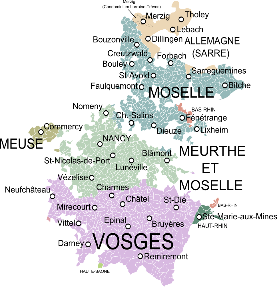
English: Map of the Duchy of Lorraine, France, showing the communes according to the current administrative division.
Français : Carte du duché de Lorraine (au milieu du XVIIIe siècle) montrant les communes et les départements actuels. |
| Date | |
| Source | Carte de la Lorraine et du Barrois dans laquelle se trouvent la Généralité de Metz et autres enclaves, Dressée pour la lecture du Mémoire de M. Durival l'ainé et dédiée au Roy de Pologne Duc de Lorraine et de Bar, Robert de Vaugondy, 1756. |
| Author | Oie blanche |
Licensing
I, the copyright holder of this work, hereby publish it under the following licenses:
This file is licensed under the Creative Commons Attribution-Share Alike 3.0 Unported license.
- You are free:
- to share – to copy, distribute and transmit the work
- to remix – to adapt the work
- Under the following conditions:
- attribution – You must give appropriate credit, provide a link to the license, and indicate if changes were made. You may do so in any reasonable manner, but not in any way that suggests the licensor endorses you or your use.
- share alike – If you remix, transform, or build upon the material, you must distribute your contributions under the same or compatible license as the original.

|
Permission is granted to copy, distribute and/or modify this document under the terms of the GNU Free Documentation License, Version 1.2 or any later version published by the Free Software Foundation; with no Invariant Sections, no Front-Cover Texts, and no Back-Cover Texts. A copy of the license is included in the section entitled GNU Free Documentation License. |
You may select the license of your choice.
File history
Click on a date/time to view the file as it appeared at that time.
| Date/Time | Thumbnail | Dimensions | User | Comment | |
|---|---|---|---|---|---|
| current | 22:12, 4 December 2013 | | 2,691 × 2,841 (831 KB) | Oie blanche | Minor edits. |
| 14:57, 3 December 2013 |  | 2,691 × 2,841 (792 KB) | Oie blanche | Minor edit. | |
| 13:42, 3 December 2013 |  | 2,691 × 2,841 (776 KB) | Oie blanche | Minor edit. | |
| 14:28, 1 December 2013 |  | 2,691 × 2,841 (855 KB) | Oie blanche | Minor correction. | |
| 14:23, 1 December 2013 |  | 2,691 × 2,841 (851 KB) | Oie blanche | {{Information |Description ={{en|1=Map of the Duchy of Lorraine, France, showing the communes according to the current administrative division.}} {{fr|1=Carte du duché de Lorraine montrant les communes et les départements actuels.}} |Source ... |
File usage
The following pages on the English Wikipedia use this file (pages on other projects are not listed):
Global file usage
The following other wikis use this file:
- Usage on de.wikipedia.org
- Usage on es.wikipedia.org
- Usage on fr.wikipedia.org
- Usage on ko.wikipedia.org
- Usage on lb.wikipedia.org
- Usage on nl.wikipedia.org
- Usage on vi.wikipedia.org