
File:Caroline Islands-map.gif
No higher resolution available.
Caroline_Islands-map.gif (326 × 350 pixels, file size: 9 KB, MIME type: image/gif)
| This is a file from the Wikimedia Commons. Information from its description page there is shown below. Commons is a freely licensed media file repository. You can help. |

|
This map image could be re-created using vector graphics as an SVG file. This has several advantages; see Commons:Media for cleanup for more information. If an SVG form of this image is available, please upload it and afterwards replace this template with
{{vector version available|new image name}}.
It is recommended to name the SVG file “Caroline Islands-map.svg”—then the template Vector version available (or Vva) does not need the new image name parameter. |
Summary
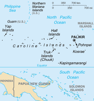
- English: Map of the Caroline Islands Archipelago — located in the Micronesia region of Oceania, in the western Pacific Ocean.
- The central and western islands are in the Federated States of Micronesia, and the eastern are in the Republic of Palau.
- The archipelago is north of the island of New Guinea and the Salomon Islands Archipelago.
Credits
- From https://www.cia.gov/library/publications/the-world-factbook/geos/fm.html archive copy at the Wayback Machine
This image is in the public domain because it contains materials that originally came from the United States Central Intelligence Agency's World Factbook.
|
 |
File history
Click on a date/time to view the file as it appeared at that time.
| Date/Time | Thumbnail | Dimensions | User | Comment | |
|---|---|---|---|---|---|
| current | 17:07, 19 June 2010 | | 326 × 350 (9 KB) | Ras67 | cropped |
| 17:27, 10 August 2005 |  | 330 × 354 (10 KB) | Bradipus | Caroline Islands From http://www.cia.gov/cia/publications/factbook/geos/fm.html {{PD-USGov-CIA-WF}} |
File usage
The following pages on the English Wikipedia use this file (pages on other projects are not listed):
Global file usage
The following other wikis use this file:
- Usage on af.wikipedia.org
- Usage on azb.wikipedia.org
- Usage on az.wikipedia.org
- Usage on cs.wikipedia.org
- Usage on es.wikipedia.org
- Usage on fa.wikipedia.org
- Usage on he.wikipedia.org
- Usage on hi.wikipedia.org
- Usage on hsb.wikipedia.org
- Usage on hu.wikipedia.org
- Usage on hy.wikipedia.org
- Usage on id.wikipedia.org
- Usage on io.wikipedia.org
- Usage on ja.wikipedia.org
- Usage on ka.wikipedia.org
- Usage on ko.wikipedia.org
- Usage on mk.wikipedia.org
- Usage on mn.wikipedia.org
- Usage on ms.wikipedia.org
- Usage on nl.wikipedia.org
- Usage on pa.wikipedia.org
- Usage on pl.wikipedia.org
- Usage on ps.wikipedia.org
- Usage on pt.wikipedia.org
- Usage on ru.wikipedia.org
- Usage on sl.wikipedia.org
- Usage on th.wikipedia.org
- Usage on tl.wikipedia.org
- Usage on tr.wikipedia.org
- Usage on uk.wikipedia.org
- Usage on vi.wikipedia.org
- Usage on war.wikipedia.org