
File:Canton River and adjacent islands.jpg

Size of this preview: 632 × 599 pixels. Other resolutions: 253 × 240 pixels | 506 × 480 pixels | 810 × 768 pixels | 1,080 × 1,024 pixels | 2,160 × 2,048 pixels | 4,952 × 4,695 pixels.
Original file (4,952 × 4,695 pixels, file size: 5.44 MB, MIME type: image/jpeg)
| This is a file from the Wikimedia Commons. Information from its description page there is shown below. Commons is a freely licensed media file repository. You can help. |
Summary
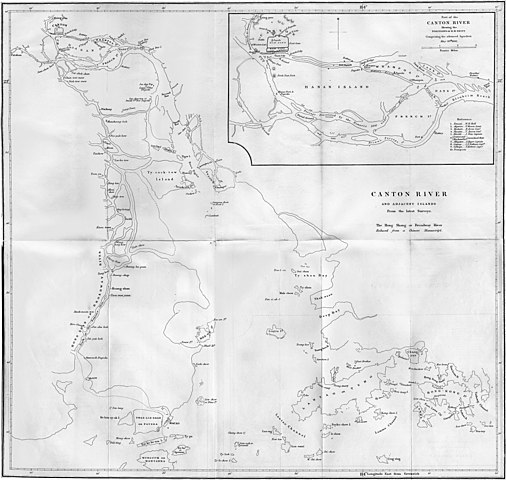
| Description | Map of the Canton River and adjacent islands. The inset shows the position of British ships comprising the advanced squadron on 26 May 1841. |
| Date | published 1844 |
| Source | William Dallas Bernard; William Hutcheon Hall (1844). Narrative of the Voyages and Services of the Nemesis, from 1840 to 1843. Volume 1. London: Henry Colburn. |
| Author | Isaac Purdy |
| Other versions | File:Map of Canton River.jpg |
Licensing
|
This work is in the public domain in its country of origin and other countries and areas where the copyright term is the author's life plus 100 years or fewer. This work is in the public domain in the United States because it was published (or registered with the U.S. Copyright Office) before January 1, 1929. | |
| This file has been identified as being free of known restrictions under copyright law, including all related and neighboring rights. | |
File history
Click on a date/time to view the file as it appeared at that time.
| Date/Time | Thumbnail | Dimensions | User | Comment | |
|---|---|---|---|---|---|
| current | 13:23, 31 October 2010 | | 4,952 × 4,695 (5.44 MB) | Spellcast | == {{int:filedesc}} == {{Information |Description=Map of the Canton River and adjacent islands. |Date=Published 1844 |Source=William Dallas Bernard; William Hutcheon Hall (1844). ''[http://www.elibron.com/maps/?msg_id=172640 Narrative of the Voyages and S |
File usage
The following pages on the English Wikipedia use this file (pages on other projects are not listed):
Global file usage
The following other wikis use this file:
- Usage on azb.wikipedia.org
- Usage on fr.wikipedia.org
- Usage on id.wikipedia.org
- Usage on vi.wikipedia.org
- Usage on zh-yue.wikipedia.org
- Usage on zh.wikipedia.org