
File:Canadian postal district map (without legends).svg

Size of this PNG preview of this SVG file: 709 × 600 pixels. Other resolutions: 284 × 240 pixels | 567 × 480 pixels | 908 × 768 pixels | 1,210 × 1,024 pixels | 2,421 × 2,048 pixels | 1,000 × 846 pixels.
Original file (SVG file, nominally 1,000 × 846 pixels, file size: 221 KB)
| This is a file from the Wikimedia Commons. Information from its description page there is shown below. Commons is a freely licensed media file repository. You can help. |
.svg)
| Description |
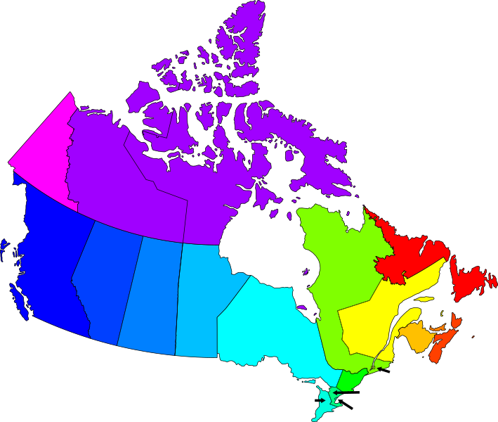
English: Derivative of Canadian postal district map.svg, but with the letters removed. This version is for overlaying hyperlinks on.
Legend: A: Newfoundland and Labrador
B: Nova Scotia
C: Prince Edward Island
E: New Brunswick
G: Eastern Quebec
H: Metropolitan Montreal
J: Western & Northern Quebec
K: Eastern Ontario
L: Central Ontario
M: Metropolitan Toronto
N: Western Ontario
P: Northern Ontario
R: Manitoba
S: Saskatchewan
T: Alberta
V: British Columbia
X: Nunavut & the Northwest Territories
Y: Yukon
Français : Dérivé de Canadian postal district map.svg. Les lettres ont été supprimées, de sorte que des hyperliens peuvent être ajoutés.
Légende: A: Terre-Neuve et Labrador
B: Nouvelle-Écosse
C: Île-du-Prince-Édouard
E: Nouveau-Brunswick
G: Est du Québec
H: Grand Montréal
J: Ouest et Nord du Québec
K: Est de l'Ontario
L: Centre de l'Ontario
M: Toronto Métropolitain
N: Ouest de l'Ontario
P: Nord de l'Ontario
R: Manitoba
S: Saskatchewan
T: Alberta
V: Colombie-Britannique
X: Nunavut et les Territoires du Nord-Ouest
Y: Yukon
|
||
| Date | |||
| Source | Own work | ||
| Author | Denelson83 | ||
| Permission (Reusing this file) |
|
File history
Click on a date/time to view the file as it appeared at that time.
| Date/Time | Thumbnail | Dimensions | User | Comment | |
|---|---|---|---|---|---|
| current | 01:07, 14 February 2009 | | 1,000 × 846 (221 KB) | Denelson83 | {{Information |Description={{en|1=Derivative of Image:Canadian postal district map.svg, but with the letters removed. This version is for overlaying hyperlinks on.}} |Source=Own work by uploader |Author=Denelson83 |Date=2009-02- |
File usage
The following pages on the English Wikipedia use this file (pages on other projects are not listed):
- List of postal codes of Canada: A
- List of postal codes of Canada: B
- List of postal codes of Canada: C
- List of postal codes of Canada: E
- List of postal codes of Canada: G
- List of postal codes of Canada: H
- List of postal codes of Canada: J
- List of postal codes of Canada: K
- List of postal codes of Canada: L
- List of postal codes of Canada: M
- List of postal codes of Canada: N
- List of postal codes of Canada: P
- List of postal codes of Canada: R
- List of postal codes of Canada: S
- List of postal codes of Canada: T
- List of postal codes of Canada: V
- List of postal codes of Canada: X
- List of postal codes of Canada: Y
- Postal codes in Canada
- Template:Canadian postal codes
Global file usage
The following other wikis use this file:
- Usage on fa.wikipedia.org
- Usage on fr.wikipedia.org
- Code postal au Canada
- Modèle:Codes postaux canadiens
- Liste des codes postaux canadiens débutant par G
- Liste des codes postaux canadiens débutant par C
- Liste des codes postaux canadiens débutant par A
- Liste des codes postaux canadiens débutant par H
- Liste des codes postaux canadiens débutant par B
- Liste des codes postaux canadiens débutant par E
- Liste des codes postaux canadiens débutant par J
- Liste des codes postaux canadiens débutant par K
- Liste des codes postaux canadiens débutant par L
- Liste des codes postaux canadiens débutant par M
- Liste des codes postaux canadiens débutant par N
- Liste des codes postaux canadiens débutant par P
- Liste des codes postaux canadiens débutant par R
- Liste des codes postaux canadiens débutant par S
- Liste des codes postaux canadiens débutant par T
- Liste des codes postaux canadiens débutant par V
- Liste des codes postaux canadiens débutant par X
- Liste des codes postaux canadiens débutant par Y
- Discussion Projet:Canada/Archive 3
- Usage on th.wikipedia.org
.svg)