
File:Caislean Rathanain (Castle Rahinanne) - geograph.org.uk - 219820.jpg
No higher resolution available.
Caislean_Rathanain_(Castle_Rahinanne)_-_geograph.org.uk_-_219820.jpg (600 × 450 pixels, file size: 58 KB, MIME type: image/jpeg)
| This is a file from the Wikimedia Commons. Information from its description page there is shown below. Commons is a freely licensed media file repository. You can help. |
_-_geograph.org.uk_-_219820.jpg)
Summary
| Description |
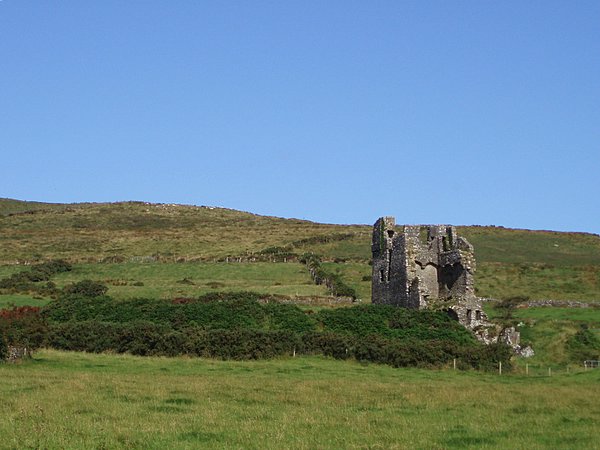
English: Caislean Rathanain (Castle Rahinanne) The castle has a fantastic view of Ventry harbour. Originally a medieval rath (domestic ring fort) stood on this site. In the 15th century a Fitzgerald knight of Kerry built the castle. On 5th March 1602 Elizabethan forces took over the castle (the knights had become rebellious). Ultimately the castle was mostly destroyed in the Cromwellian wars 50 years later, although it remained as a diminished family residence until the 18th century. It is 40ft long and 20ft wide, and is of a 'tower house' type. |
| Date | |
| Source | From geograph.org.uk |
| Author | Sharon Loxton |
| Attribution (required by the license) | Sharon Loxton / Caislean Rathanain (Castle Rahinanne) / |
| Camera location | | View this and other nearby images on: OpenStreetMap |
|---|
_-_geograph.org.uk_-_219820.jpg¶ms=052.141300_N_-010.382000_E_globe:Earth_type:camera_source:geograph-irishgrid(Q369014)_&language=en)
| Object location | | View this and other nearby images on: OpenStreetMap |
|---|
_-_geograph.org.uk_-_219820.jpg¶ms=052.143100_N_-010.383000_E_globe:Earth_class:object_type:object_source:geograph-irishgrid(Q369016)_&language=en)
Licensing

|
This image was taken from the Geograph project collection. See this photograph's page on the Geograph website for the photographer's contact details. The copyright on this image is owned by Sharon Loxton and is licensed for reuse under the Creative Commons Attribution-ShareAlike 2.0 license.
|
This file is licensed under the Creative Commons Attribution-Share Alike 2.0 Generic license.
Attribution: Sharon Loxton
- You are free:
- to share – to copy, distribute and transmit the work
- to remix – to adapt the work
- Under the following conditions:
- attribution – You must give appropriate credit, provide a link to the license, and indicate if changes were made. You may do so in any reasonable manner, but not in any way that suggests the licensor endorses you or your use.
- share alike – If you remix, transform, or build upon the material, you must distribute your contributions under the same or compatible license as the original.
File history
Click on a date/time to view the file as it appeared at that time.
| Date/Time | Thumbnail | Dimensions | User | Comment | |
|---|---|---|---|---|---|
| current | 20:34, 31 January 2010 | | 600 × 450 (58 KB) | GeographBot | == {{int:filedesc}} == {{Information |description={{en|1=Caislean Rathanain (Castle Rahinanne) The castle has a fantastic view of Ventry harbour. Originally a medieval rath (domestic ring fort) stood on this site. In the 15th century a Fitzgerald knight |
File usage
The following pages on the English Wikipedia use this file (pages on other projects are not listed):
Global file usage
The following other wikis use this file:
- Usage on de.wikipedia.org
- Usage on uk.wikipedia.org
_-_geograph.org.uk_-_219820.jpg)