
File:Cairo 1992 Isoseismal Map.PNG

Size of this preview: 506 × 599 pixels. Other resolutions: 203 × 240 pixels | 405 × 480 pixels | 648 × 768 pixels | 864 × 1,024 pixels | 1,458 × 1,727 pixels.
Original file (1,458 × 1,727 pixels, file size: 426 KB, MIME type: image/png)
| This is a file from the Wikimedia Commons. Information from its description page there is shown below. Commons is a freely licensed media file repository. You can help. |
Summary
| Description |
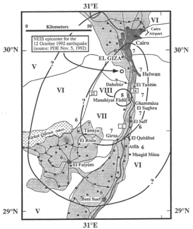
English: Isoseismal map for the 1992 Dahshur earthquake near Cairo, Egypt |
| Date | |
| Source | USGS Open File Report 93-181 |
| Author | USGS |
| Other versions | العربيَّة |
Licensing
This image is in the public domain in the United States because it only contains materials that originally came from the United States Geological Survey, an agency of the United States Department of the Interior. For more information, see the official USGS copyright policy.
|
File history
Click on a date/time to view the file as it appeared at that time.
| Date/Time | Thumbnail | Dimensions | User | Comment | |
|---|---|---|---|---|---|
| current | 19:54, 9 June 2010 | | 1,458 × 1,727 (426 KB) | Mikenorton | {{Information |Description={{en|1=Isoseismal map for the 1992 Dahshur earthquake near Cairo, Egypt}} |Source=USGS Open File Report 93-181 |Author=USGS |Date=1993 |Permission= |other_versions= }} Category:Earthquake maps Category:Egypt |
File usage
The following pages on the English Wikipedia use this file (pages on other projects are not listed):
Global file usage
The following other wikis use this file:
- Usage on ar.wikipedia.org
- Usage on fr.wiktionary.org
- Usage on sr.wikipedia.org
- Usage on uk.wikipedia.org