
File:Cadiz Wilderness and Valley.jpg

Original file (2,000 × 1,333 pixels, file size: 989 KB, MIME type: image/jpeg)
| This is a file from the Wikimedia Commons. Information from its description page there is shown below. Commons is a freely licensed media file repository. You can help. |
Summary
| Description |
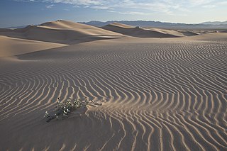
English: These small dunes were formed by north winds pushing sands off the Cadiz Dry Lake. The pristine nature of the dunes and the beautiful spring display of unique dune plants have made the area a favorite for photographers.
On February 12, 2016, President Obama signed a proclamation declaring the Mojave Trails National Monument east of Los Angeles in Southern California. Mojave Trails National Monument: Spanning 1.6 million acres, more than 350,000 acres of previously congressionally-designated Wilderness, the Mojave Trails National Monument is comprised of a stunning mosaic of rugged mountain ranges, ancient lava flows, and spectacular sand dunes. The monument will protect irreplaceable historic resources including ancient Native American trading routes, World War II-era training camps, and the longest remaining undeveloped stretch of Route 66. Additionally, the area has been a focus of study and research for decades, including geological research and ecological studies on the effects of climate change and land management practices on ecological communities and wildlife. Photo by Bob Wick, BLM. |
| Date | |
| Source | https://www.flickr.com/photos/blmcalifornia/24849806461/ |
| Author | Bureau of Land Management California |
Licensing
| This image was originally posted to Flickr by blmcalifornia at https://flickr.com/photos/50976304@N07/24849806461. It was reviewed on 11 May 2023 by FlickreviewR 2 and was confirmed to be licensed under the terms of the Public Domain Mark. |
| This image is a work of a Bureau of Land Management* employee, taken or made as part of that person's official duties. As a work of the U.S. federal government, the image is in the public domain in the United States. *or predecessor organization |
File history
Click on a date/time to view the file as it appeared at that time.
| Date/Time | Thumbnail | Dimensions | User | Comment | |
|---|---|---|---|---|---|
| current | 15:26, 19 November 2020 | | 2,000 × 1,333 (989 KB) | Originalhistorywriter | Uploaded a work by Bureau of Land Management California from https://www.flickr.com/photos/blmcalifornia/24849806461/ with UploadWizard |