
File:COVID-19 in Columbus.svg

Size of this PNG preview of this SVG file: 512 × 331 pixels. Other resolutions: 320 × 207 pixels | 640 × 414 pixels | 1,024 × 662 pixels | 1,280 × 828 pixels | 2,560 × 1,655 pixels.
Original file (SVG file, nominally 512 × 331 pixels, file size: 182 KB)
| This is a file from the Wikimedia Commons. Information from its description page there is shown below. Commons is a freely licensed media file repository. You can help. |
Summary
| Description |
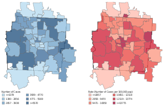
English: Coronavirus in Columbus, Ohio. |
| Date | |
| Source | City of Columbus and Franklin County Jurisdictions: Coronavirus Disease 2019 (COVID-19) Summary of Cases. City of Columbus (September 22, 2021). Retrieved on September 22, 2021. |
| Author | City of Columbus, US Census population data, USPS postal zone map |
Licensing
| This map is ineligible for copyright and therefore in the public domain, because it consists entirely of information that is common property and contains no original authorship. For more information, see Commons:Threshold of originality § Maps.
|
File history
Click on a date/time to view the file as it appeared at that time.
| Date/Time | Thumbnail | Dimensions | User | Comment | |
|---|---|---|---|---|---|
| current | 16:24, 24 September 2021 | | 512 × 331 (182 KB) | Ɱ | Sept 22 |
| 17:13, 12 March 2021 |  | 512 × 336 (184 KB) | Ɱ | update | |
| 21:34, 19 November 2020 |  | 512 × 328 (182 KB) | Ɱ | new | |
| 00:43, 25 September 2020 |  | 752 × 467 (446 KB) | Ɱ | update | |
| 17:32, 2 July 2020 |  | 733 × 467 (421 KB) | Ɱ | update | |
| 03:46, 6 June 2020 |  | 751 × 469 (496 KB) | Ɱ | update | |
| 00:21, 10 May 2020 |  | 628 × 435 (483 KB) | Ɱ | May 8 | |
| 20:29, 1 May 2020 |  | 689 × 446 (431 KB) | Ɱ | May 1 update | |
| 02:18, 19 April 2020 |  | 761 × 494 (422 KB) | Ɱ | Uploaded a work by City of Columbus, US Census population data, USPS postal zone map from {{cite web|title=City of Columbus and Franklin County Jurisdictions: Coronavirus Disease 2019 (COVID-19) Summary of Cases|publisher=City of Columbus|url=https://www.columbus.gov/WorkArea/DownloadAsset.aspx?id=2147514955|date=April 17, 2020|accessdate=April 18, 2020}} with UploadWizard |
File usage
No pages on the English Wikipedia use this file (pages on other projects are not listed).