
File:COVID-19 Prevalence in California by county.svg

Size of this PNG preview of this SVG file: 338 × 400 pixels. Other resolutions: 203 × 240 pixels | 406 × 480 pixels | 649 × 768 pixels | 865 × 1,024 pixels | 1,730 × 2,048 pixels.
Original file (SVG file, nominally 338 × 400 pixels, file size: 74 KB)
| This is a file from the Wikimedia Commons. Information from its description page there is shown below. Commons is a freely licensed media file repository. You can help. |
Summary
| Description |
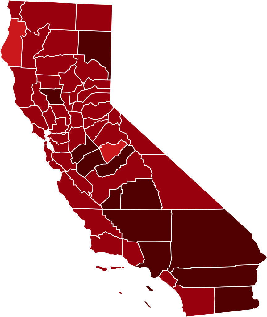
This map shows confirmed cases of w:en:COVID-19, coded by percentage of population confirmed to be infected as of 29 March 2021. The data is used from the data as aggregated and released by Johns Hopkins University and US census (2019 population estimate). As this is a current outbreak, the map might not be up to date. 10.00%+ Confirmed infected
3.00%-10.00% Confirmed infected
1.00%-3.00% Confirmed infected
0.30%-1.00% Confirmed infected
0.10%-0.30% Confirmed infected
0.03%-0.10% Confirmed infected
0.00%-0.03% Confirmed infected
no confirmed cases or no data
The design is based on blank maps available in Public Domain (created by Yiling Chen from TIGER shapefiles), the color scheme is based on color brewer. The script for creating the maps was written by Sukolsak Sakshuwong and Lodewijk Gelauff.
|
||||
| Date | |||||
| Source | Based on File:Blank_California_Map.svg by user:Thadius856 | ||||
| Author | The design is based on blank maps available in Public Domain, the color scheme is based on the design created by platypeanArchcow (PD). The script for creating the maps was written by Sukolsak Sakshuwong and Lodewijk Gelauff. |

Licensing
| I, the copyright holder of this work, release this work into the public domain. This applies worldwide. In some countries this may not be legally possible; if so: I grant anyone the right to use this work for any purpose, without any conditions, unless such conditions are required by law. |
File history
Click on a date/time to view the file as it appeared at that time.
| Date/Time | Thumbnail | Dimensions | User | Comment | |
|---|---|---|---|---|---|
| current | 06:17, 14 March 2021 | | 338 × 400 (74 KB) | Eiabot | new data: 13 March 2021 |
| 07:59, 2 March 2021 |  | 338 × 400 (74 KB) | Eiabot | new data: 01 March 2021 | |
| 06:23, 21 February 2021 |  | 338 × 400 (74 KB) | Eiabot | new data: 20 February 2021 | |
| 06:58, 18 February 2021 |  | 338 × 400 (74 KB) | Eiabot | new data: 17 February 2021 | |
| 07:00, 14 February 2021 |  | 338 × 400 (74 KB) | Eiabot | new data: 13 February 2021 | |
| 06:32, 27 January 2021 |  | 338 × 400 (74 KB) | Eiabot | new data: 26 January 2021 | |
| 07:58, 26 January 2021 |  | 338 × 400 (74 KB) | Eiabot | new data: 25 January 2021 | |
| 06:52, 20 January 2021 |  | 338 × 400 (74 KB) | Eiabot | new data: 19 January 2020 | |
| 06:43, 17 January 2021 |  | 338 × 400 (74 KB) | Eiabot | new data: 16 January 2020 | |
| 06:16, 16 January 2021 |  | 338 × 400 (74 KB) | Eiabot | new data: 15 January 2020 |
File usage
The following pages on the English Wikipedia use this file (pages on other projects are not listed):
Global file usage
The following other wikis use this file:
- Usage on ar.wikipedia.org
- Usage on es.wikipedia.org
- Usage on fa.wikipedia.org
- Usage on id.wikipedia.org
- Usage on it.wikipedia.org
- Usage on zh.wikipedia.org