
File:CLOSE- UP OF TRIGLYPHS, ALSO PILASTER CAP ON S. W. CORNER OF BUILDING - Christ Episcopal Church, Church and Saint HABS ALA,49-MOBI,33-10.tif

Size of this JPG preview of this TIF file: 432 × 599 pixels. Other resolutions: 173 × 240 pixels | 346 × 480 pixels | 553 × 768 pixels | 738 × 1,024 pixels | 1,476 × 2,048 pixels | 3,604 × 5,000 pixels.
Original file (3,604 × 5,000 pixels, file size: 17.19 MB, MIME type: image/tiff)
| This is a file from the Wikimedia Commons. Information from its description page there is shown below. Commons is a freely licensed media file repository. You can help. |
Summary
| Historic American Buildings Survey E. W. Russell, Photographer, August 28, 1936 CLOSE- UP OF TRIGLYPHS, ALSO PILASTER CAP ON S. W. CORNER OF BUILDING - Christ Episcopal Church, Church and Saint Emanuel Streets, Mobile, Mobile County, AL | ||||
|---|---|---|---|---|
| Title |
Historic American Buildings Survey E. W. Russell, Photographer, August 28, 1936 CLOSE- UP OF TRIGLYPHS, ALSO PILASTER CAP ON S. W. CORNER OF BUILDING - Christ Episcopal Church, Church and Saint Emanuel Streets, Mobile, Mobile County, AL |
|||
| Depicted place | Alabama; Mobile County; Mobile | |||
| Date | Documentation compiled after 1933 | |||
| Medium | 5 x 7 in. | |||
| Current location |
Library of Congress Prints and Photographs Division Washington, D.C. 20540 USA http://hdl.loc.gov/loc.pnp/pp.print |
|||
| Accession number |
HABS ALA,49-MOBI,33-10 |
|||
| Credit line |
|
|||
| Notes |
|
|||
| Source | https://www.loc.gov/pictures/item/al0423.photos.313841p | |||
| Permission (Reusing this file) |
|
|||

| Object location | | View this and other nearby images on: OpenStreetMap |
|---|
File history
Click on a date/time to view the file as it appeared at that time.
| Date/Time | Thumbnail | Dimensions | User | Comment | |
|---|---|---|---|---|---|
| current | 17:49, 29 June 2014 | 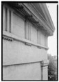 | 3,604 × 5,000 (17.19 MB) | Fæ | GWToolset: Creating mediafile for Fæ. HABS batch upload restart 26 June 2014 (p21:101)x |
File usage
The following pages on the English Wikipedia use this file (pages on other projects are not listed):
Global file usage
The following other wikis use this file:
- Usage on ru.wiktionary.org