
File:CDC map of Zika virus distribution as of 15 January 2016.png
No higher resolution available.
CDC_map_of_Zika_virus_distribution_as_of_15_January_2016.png (800 × 480 pixels, file size: 299 KB, MIME type: image/png)
| This is a file from the Wikimedia Commons. Information from its description page there is shown below. Commons is a freely licensed media file repository. You can help. |
This file supersedes the file CDC map of Zika virus distribution in January 2016.jpg. It is recommended to use this file rather than the other one.
|
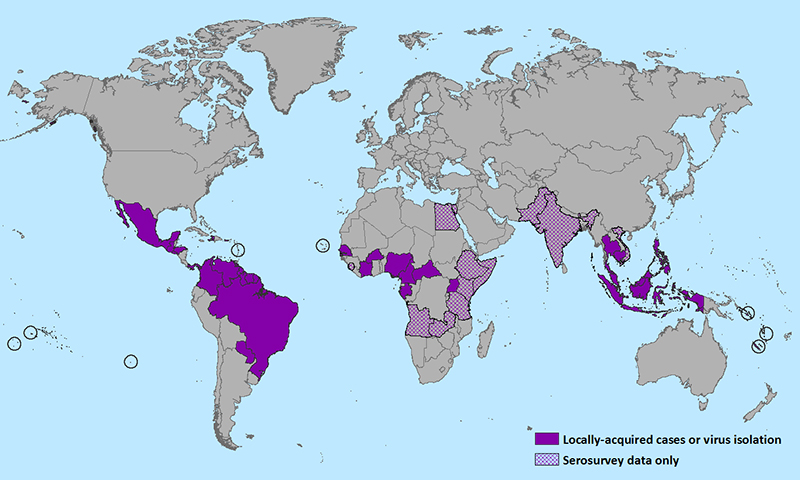
| Description | Centers for Disease Control and Prevention map of the geographic distribution of Zika virus as of 15 January 2015 | |||
| Date | ||||
| Source | https://www.cdc.gov/zika/images/zik-world-map_01-15-2016_web.jpg | |||
| Author | United States Centers for Disease Control and Prevention | |||
| Permission (Reusing this file) |
|

|
This biogeographical map image could be re-created using vector graphics as an SVG file. This has several advantages; see Commons:Media for cleanup for more information. If an SVG form of this image is available, please upload it and afterwards replace this template with
{{vector version available|new image name}}.
It is recommended to name the SVG file “CDC map of Zika virus distribution as of 15 January 2016.svg”—then the template Vector version available (or Vva) does not need the new image name parameter. |
File history
Click on a date/time to view the file as it appeared at that time.
| Date/Time | Thumbnail | Dimensions | User | Comment | |
|---|---|---|---|---|---|
| current | 21:48, 26 January 2016 | | 800 × 480 (299 KB) | Mardus | {{Supersedes|1=CDC map of Zika virus distribution in January 2016.jpg}} {{Information |Description=Centers for Disease Control and Prevention map of the geographic distribution of Zika virus as of '''15 January 2015''' |Source=http://www.cdc.gov/zika/i... |
File usage
The following pages on the English Wikipedia use this file (pages on other projects are not listed):
Global file usage
The following other wikis use this file:
- Usage on bg.wikipedia.org
- Usage on es.wikipedia.org
- Usage on eu.wikipedia.org
- Usage on fa.wikipedia.org
- Usage on he.wikipedia.org
- Usage on hy.wikipedia.org
- Usage on ja.wikipedia.org
- Usage on pt.wikipedia.org