
File:Côtes de France.jpg
Size of this preview: 632 × 600 pixels. Other resolutions: 253 × 240 pixels | 506 × 480 pixels | 809 × 768 pixels | 1,079 × 1,024 pixels | 2,005 × 1,903 pixels.
Original file (2,005 × 1,903 pixels, file size: 1.48 MB, MIME type: image/jpeg)
| This is a file from the Wikimedia Commons. Information from its description page there is shown below. Commons is a freely licensed media file repository. You can help. |
Summary
| Description |
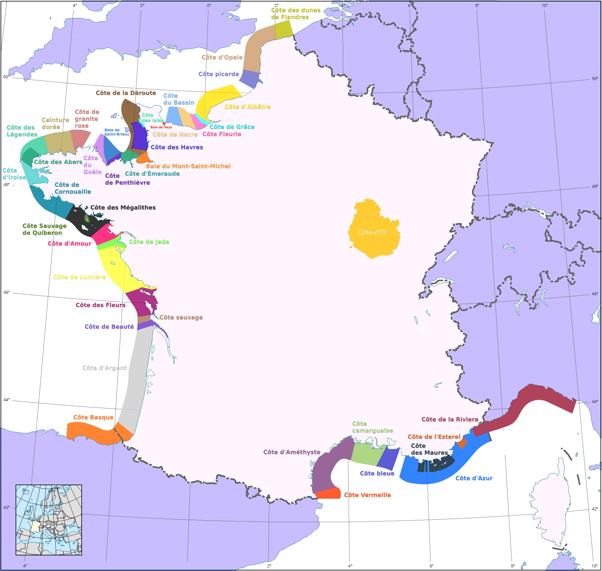
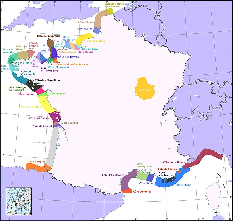
English: Map of the "Côtes" of France. Littoral parts that are named.
The département of Côte-d'Or appears because the coastlines are named from derivates of its name (Côte d'or means gold coast).
Français : Carte des différentes côtes de France.
Le département de la Côte-d'Or apparaît car son nom a été source d'inspiration pour Stéphen Liégeard pour le nom de la Côte d'Azur. |
| Date | |
| Source | Own work |
| Author | Rigil |
| Other versions | File:Côtes de France 2.jpg (sans la Côte d'Or) |
Réalisé à partir de cette carte : File:France map Lambert-93-blank.svg

|
This map image could be re-created using vector graphics as an SVG file. This has several advantages; see Commons:Media for cleanup for more information. If an SVG form of this image is available, please upload it and afterwards replace this template with
{{vector version available|new image name}}.
It is recommended to name the SVG file “Côtes de France.svg”—then the template Vector version available (or Vva) does not need the new image name parameter. |


Licensing
I, the copyright holder of this work, hereby publish it under the following licenses:

|
Permission is granted to copy, distribute and/or modify this document under the terms of the GNU Free Documentation License, Version 1.2 or any later version published by the Free Software Foundation; with no Invariant Sections, no Front-Cover Texts, and no Back-Cover Texts. A copy of the license is included in the section entitled GNU Free Documentation License. |
This file is licensed under the Creative Commons Attribution-Share Alike 3.0 Unported, 2.5 Generic, 2.0 Generic and 1.0 Generic license.
- You are free:
- to share – to copy, distribute and transmit the work
- to remix – to adapt the work
- Under the following conditions:
- attribution – You must give appropriate credit, provide a link to the license, and indicate if changes were made. You may do so in any reasonable manner, but not in any way that suggests the licensor endorses you or your use.
- share alike – If you remix, transform, or build upon the material, you must distribute your contributions under the same or compatible license as the original.
You may select the license of your choice.
File history
Click on a date/time to view the file as it appeared at that time.
| Date/Time | Thumbnail | Dimensions | User | Comment | |
|---|---|---|---|---|---|
| current | 23:25, 19 July 2022 | | 2,005 × 1,903 (1.48 MB) | Rundvald | Mise à jour - rajout de côtes - correction des délimitations géographiques de certaines côtes - amélioration lisibilité police de caractère - changement de certaines couleurs pour plus de lisibilité de la carte. |
| 00:39, 11 February 2017 |  | 2,005 × 1,903 (541 KB) | Zorion | côte basque | |
| 19:53, 13 October 2010 |  | 2,005 × 1,903 (1.14 MB) | Rigil~commonswiki | Changement de couleurs. Mise à jour. | |
| 13:20, 5 October 2010 |  | 2,005 × 1,903 (834 KB) | Rigil~commonswiki | Mise à jour | |
| 12:51, 5 October 2010 |  | 2,005 × 1,903 (816 KB) | Rigil~commonswiki | {{Information |Description={{en|1=Map of the "Côtes" of France. Littoral parts that are named. The département of Côte-d'Or appears because the coastlines are named from derivates of its name (Côte d'or means gold coast).}} {{fr|1=Cartes des différen |
File usage
The following pages on the English Wikipedia use this file (pages on other projects are not listed):
Global file usage
The following other wikis use this file:
- Usage on cs.wikipedia.org
- Usage on da.wikipedia.org
- Usage on de.wikipedia.org
- Usage on el.wikipedia.org
- Usage on eo.wikipedia.org
- Usage on es.wikipedia.org
- Usage on fi.wikipedia.org
- Usage on fr.wikipedia.org
- Usage on www.wikidata.org
- Usage on zh.wikipedia.org