
File:Cádiz-loc.svg

Size of this PNG preview of this SVG file: 512 × 580 pixels. Other resolutions: 212 × 240 pixels | 424 × 480 pixels | 678 × 768 pixels | 904 × 1,024 pixels | 1,808 × 2,048 pixels.
Original file (SVG file, nominally 512 × 580 pixels, file size: 338 KB)
| This is a file from the Wikimedia Commons. Information from its description page there is shown below. Commons is a freely licensed media file repository. You can help. |
Summary
| Description |
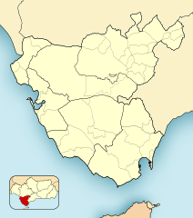
English: Location map of Cádiz
Equirectangular projection, N/S stretching 130 %. Geographic limits of the map:
Español: Mapa de localización de Cádiz
Proyección equirrectangular, N/S estirada 130 %. Límites geográficos del mapa:
|
|
| Date | ||
| Source | Own work based on: Spain location map.svg by HansenBCN | |
| Author | Miguillen | |
| SVG development |
|
Licensing
I, the copyright holder of this work, hereby publish it under the following licenses:

|
Permission is granted to copy, distribute and/or modify this document under the terms of the GNU Free Documentation License, Version 1.2 or any later version published by the Free Software Foundation; with no Invariant Sections, no Front-Cover Texts, and no Back-Cover Texts. A copy of the license is included in the section entitled GNU Free Documentation License. |
This file is licensed under the Creative Commons Attribution-Share Alike 4.0 International, 3.0 Unported, 2.5 Generic, 2.0 Generic and 1.0 Generic license.
- You are free:
- to share – to copy, distribute and transmit the work
- to remix – to adapt the work
- Under the following conditions:
- attribution – You must give appropriate credit, provide a link to the license, and indicate if changes were made. You may do so in any reasonable manner, but not in any way that suggests the licensor endorses you or your use.
- share alike – If you remix, transform, or build upon the material, you must distribute your contributions under the same or compatible license as the original.
You may select the license of your choice.
File history
Click on a date/time to view the file as it appeared at that time.
| Date/Time | Thumbnail | Dimensions | User | Comment | |
|---|---|---|---|---|---|
| current | 18:32, 1 January 2020 | | 512 × 580 (338 KB) | NACLE | añado San Martín del Tesorillo |
| 16:54, 9 December 2010 |  | 512 × 580 (334 KB) | Miguillen | colores y mosca según convención | |
| 14:24, 29 August 2010 |  | 512 × 580 (232 KB) | Miguillen | corrijo errores de proyección y corrijo error en comarcas | |
| 18:14, 14 April 2010 |  | 512 × 619 (247 KB) | Miguillen | borde externo y mapa de localización | |
| 17:39, 14 April 2010 |  | 512 × 620 (190 KB) | Miguillen | {{Information |Description=mapa de la provincia de Cádiz dividido en municipios y comarcas |Source={{own}}{{inkscape}} |Date=2010-04-14 |Author=Miguillen |Permission= |other_versions= }} Category:Maps of Cádiz |
File usage
The following pages on the English Wikipedia use this file (pages on other projects are not listed):
- 1977 European Ladies' Team Championship
- Alcalá de los Gazules
- Algeciras Heliport
- Arco de los Blanco
- Arco del Pópulo
- Arcos de la Frontera
- Baelo Claudia
- Bolonia, Spain
- Campamento (San Roque)
- Cape Trafalgar
- Castellar de la Frontera
- Chiclana de la Frontera
- Conil de la Frontera
- Doña Blanca (archaeological site)
- El Bujeo
- El Cuartón
- El Palmar de Vejer
- El Pelayo
- El Zabal
- Fuerte de Punta Carnero
- Fuerte de San Diego
- Fuerte de San García
- Guadacorte
- House of Vizarrón
- Islote de Sancti Petri
- Jimena de la Frontera
- La Alcaidesa
- La Atunara
- Los Barrios
- Los Cortijillos
- Municipal Museum of Algeciras
- Museo Arqueológico Municipal de Jerez de la Frontera
- Novo Sancti Petri
- Olvera
- Pedro Valiente
- Puente Mayorga
- Puerto Serrano
- Ruins of Fort St. Barbara
- San Pablo de Buceite
- Setenil de las Bodegas
- Sotogrande
- Tarifa
- Torre del Fraile
- Trebujena
- Ubrique
- Valdevaqueros
- Zahara de la Sierra
- User:Wjemather/European Tour maps
- Module:Location map/data/Spain Province of Cádiz
- Module:Location map/data/Spain Province of Cádiz/doc
Global file usage
The following other wikis use this file:
- Usage on ar.wikipedia.org
- Usage on az.wikipedia.org
- Usage on ba.wikipedia.org
- Usage on br.wikipedia.org
- Usage on ceb.wikipedia.org
- Usage on cs.wikipedia.org
- Usage on de.wikipedia.org
- Usage on eo.wikipedia.org
- Kadizo
- Ĝibraltara Markolo
- San-Fernando
- Provinco Kadizo
- El Puerto de Santa María
- Ŝablono:Situo sur mapo Hispanio Kadizo
- Ŝablono:Situo sur mapo Hispanio Kadizo/dokumentado
- Golfo de Algeciras
- Ŝablono:Informkesto golfo
- Ŝablono:Informkesto golfo/dokumentado
- Cádiz (stacidomo)
- Aeropuerto de Jerez (stacidomo)
- Las Aletas (stacidomo)
- Universidad de Cádiz (stacidomo)
- Jerez de la Frontera (stacidomo)
- Cortadura (stacidomo)
- San Severiano (stacidomo)
- Segunda Aguada (stacidomo)
- Estadio (stacidomo)
- Río Arillo (stacidomo)
- San Fernando-Bahía Sur (stacidomo)
- San Fernando-Centro (stacidomo)
- Puerto Real (stacidomo)
- Valdelagrana (stacidomo)
- El Puerto de Santa María (stacidomo)
- Usage on es.wikipedia.org
View more global usage of this file.