
File:Byzantine Greece ca 900 AD.svg

Size of this PNG preview of this SVG file: 756 × 599 pixels. Other resolutions: 303 × 240 pixels | 605 × 480 pixels | 969 × 768 pixels | 1,280 × 1,015 pixels | 2,560 × 2,030 pixels | 797 × 632 pixels.
Original file (SVG file, nominally 797 × 632 pixels, file size: 1.18 MB)
| This is a file from the Wikimedia Commons. Information from its description page there is shown below. Commons is a freely licensed media file repository. You can help. |
Summary
| Description |
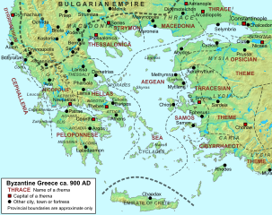
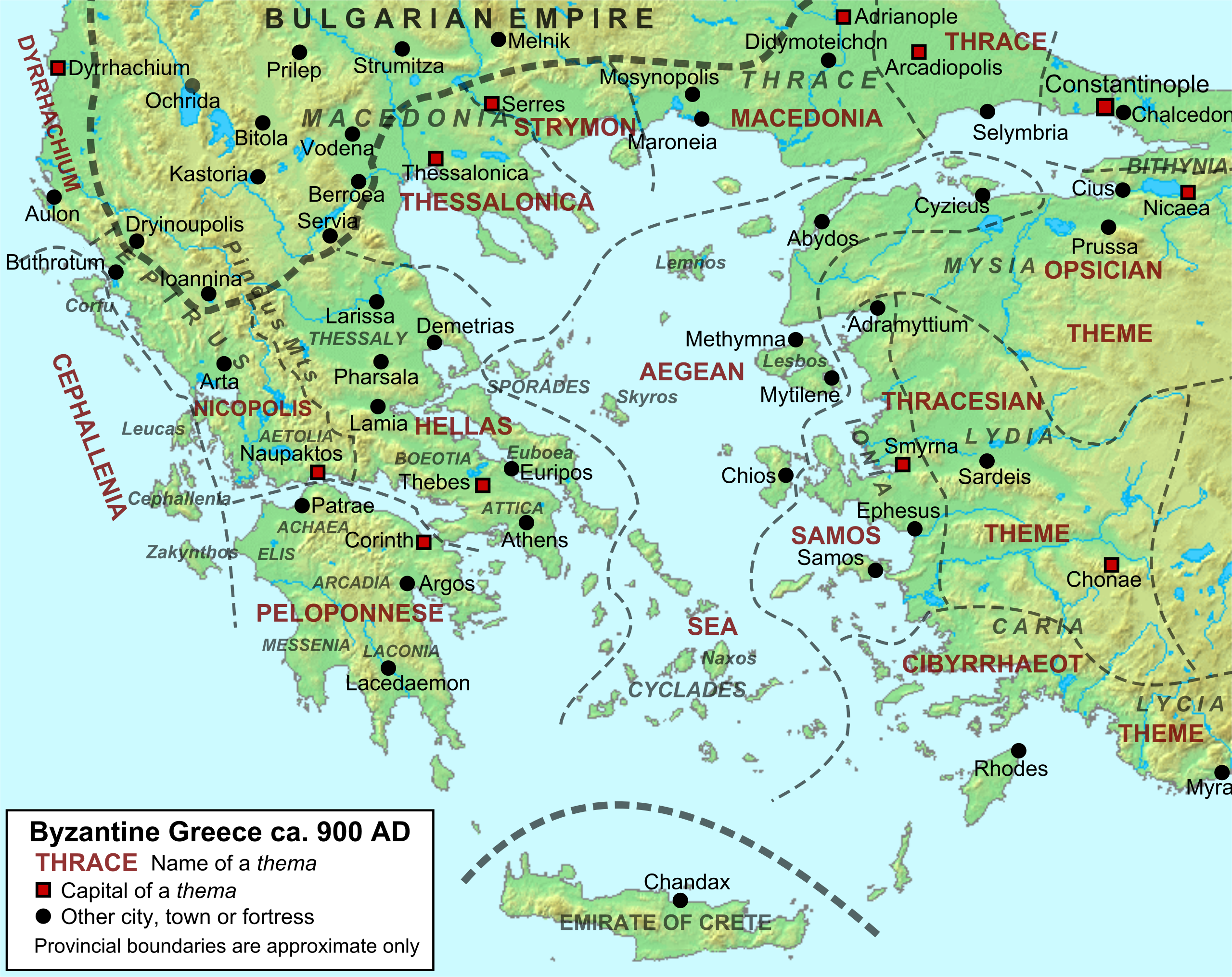
English: Byzantine Greece and the surrounding regions in ca. 900 AD, with provinces and major settlements. Topography taken from DEMIS Mapserver, which are public domain, other wise self-made. Sources: W. Treadgold, A History of the Byzantine State and Society (1997), p. 546; M. Whittow, The Making of Byzantium, 600-1025 (1996), p. 166; Droysen - Oströmisches Reich.jpg; Oxford Dictionary of Byzantium (1991), p. 871; Liz James (ed), A Companion to Byzantium (2010), p. 6; the Tabula Imperii Byzantini series. |
| Date | 1 April 2011 (upload date) |
| Source | Own work |
| Author | Cplakidas |
| Permission (Reusing this file) |
[]
|


This W3C-unspecified vector image was created with Inkscape .
Licensing
I, the copyright holder of this work, hereby publish it under the following licenses:
This file is licensed under the Creative Commons Attribution-Share Alike 3.0 Unported license.
- You are free:
- to share – to copy, distribute and transmit the work
- to remix – to adapt the work
- Under the following conditions:
- attribution – You must give appropriate credit, provide a link to the license, and indicate if changes were made. You may do so in any reasonable manner, but not in any way that suggests the licensor endorses you or your use.
- share alike – If you remix, transform, or build upon the material, you must distribute your contributions under the same or compatible license as the original.

|
Permission is granted to copy, distribute and/or modify this document under the terms of the GNU Free Documentation License, Version 1.2 or any later version published by the Free Software Foundation; with no Invariant Sections, no Front-Cover Texts, and no Back-Cover Texts. A copy of the license is included in the section entitled GNU Free Documentation License. |
You may select the license of your choice.
File history
Click on a date/time to view the file as it appeared at that time.
| Date/Time | Thumbnail | Dimensions | User | Comment | |
|---|---|---|---|---|---|
| current | 12:02, 1 April 2011 | | 797 × 632 (1.18 MB) | Cplakidas | {{Information |Description ={{en|1=Byzantine Greece and the surrounding regions in ca. 900 AD, with provinces and major settlements. Topography taken from from [http://www2.demis.nl/ DEMIS Mapserver], which are public domain, other wise self-made. Sour |
File usage
The following pages on the English Wikipedia use this file (pages on other projects are not listed):
- Achaea
- Aegean Sea (theme)
- Byzantine Greece
- Cephallenia (theme)
- Dyrrhachium (theme)
- Epirus
- Epirus (Roman province)
- Gregory Taronites
- Hellas (theme)
- History of Thessaly
- Macedonia (theme)
- Peloponnese
- Peloponnese (theme)
- Samos (theme)
- Siege of Patras (805 or 807)
- Strymon (theme)
- Thessalonica (theme)
- Zoe Zaoutzaina
- User:Cplakidas/Articles
- User:Falcaorib
Global file usage
The following other wikis use this file:
- Usage on ar.wikipedia.org
- Usage on be.wikipedia.org
- Usage on bg.wikipedia.org
- Usage on ca.wikipedia.org
- Usage on da.wikipedia.org
- Usage on de.wikipedia.org
- Usage on de.wikibooks.org
- Usage on el.wikipedia.org
- Usage on et.wikipedia.org
- Usage on fr.wikipedia.org
- Leucade
- Nicéphore Ier
- Acarnanie
- Strymon (thème)
- Hellade (thème)
- Nicopolis (thème)
- Céphalonie (thème)
- Thessalonique (thème)
- Macédoine (thème)
- Wikipédia:Atelier graphique/Cartes/Archives/Demandes mises en sommeil/Europe
- Thessalie
- Guerre byzantino-bulgare de 913-927
- Épire romaine et byzantine
- Mosynopolis
- Usage on he.wikipedia.org
- Usage on hu.wikipedia.org
- Usage on hy.wikipedia.org
- Usage on hyw.wikipedia.org
- Usage on id.wikipedia.org
View more global usage of this file.