
File:Bt-map.png
No higher resolution available.
Bt-map.png (326 × 351 pixels, file size: 7 KB, MIME type: image/png)
| This is a file from the Wikimedia Commons. Information from its description page there is shown below. Commons is a freely licensed media file repository. You can help. |
Summary
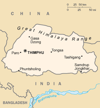
| Description | Bhutan map from CIA World Factbook |
| Date | |
| Source | CIA World Factbook, converted from original GIF format |
| Author | United States Central Intelligence Agency |
| Other versions |
|
Licensing
This image is in the public domain because it contains materials that originally came from the United States Central Intelligence Agency's World Factbook.
|
 |
Derivative works
-
 Bhutan CIA map PL.png
polski -
 Bhutan-map mk.png
македонски -
 Bt-map-ja.png
日本語 -
 Bt-map-no.png
norsk -
 Carte Bouthan.png
français -
 Mapa Bhútánu.PNG
čeština


File history
Click on a date/time to view the file as it appeared at that time.
| Date/Time | Thumbnail | Dimensions | User | Comment | |
|---|---|---|---|---|---|
| current | 03:10, 19 July 2010 | | 326 × 351 (7 KB) | Beao | Removed border. |
| 17:50, 27 February 2005 |  | 330 × 355 (8 KB) | Alfio | CIA map of Bhutan |
File usage
The following pages on the English Wikipedia use this file (pages on other projects are not listed):
Global file usage
The following other wikis use this file:
- Usage on azb.wikipedia.org
- Usage on ban.wikipedia.org
- Usage on en.wikisource.org
- Usage on fa.wikipedia.org
- Usage on kbp.wikipedia.org
- Usage on ko.wikipedia.org
- Usage on uk.wikipedia.org
- Usage on zh.wikipedia.org