
File:Bramhope Tunnel south portal.jpg
No higher resolution available.
Bramhope_Tunnel_south_portal.jpg (640 × 439 pixels, file size: 151 KB, MIME type: image/jpeg)
| This is a file from the Wikimedia Commons. Information from its description page there is shown below. Commons is a freely licensed media file repository. You can help. |
Summary
| Description |
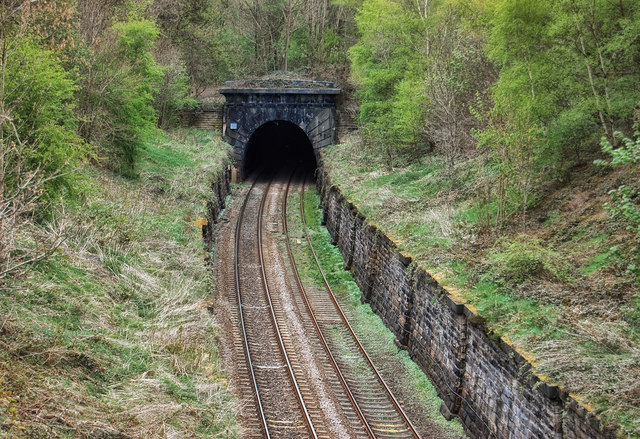
English: The south portal of the Bramhope Tunnel at grid reference SE24144077 in Bramhope, West Yorkshire, England. The rock, particularly at this end of the tunnel, proved difficult and expensive to blast during its construction in the 1850s. Flooding and subsidence also presented a constant threat - it has been estimated that in total some 1,563,480,000 gallons of water were pumped out of the workings during construction due to the gradient sloping downwards from this point as the tunnel snakes over two miles to the Arthington portal on the north side. |
| Date | |
| Source | see below |
| Author | Tom Blackwell |
| Attribution (required by the license) | Tom Blackwell / Bramhope Tunnel South Portal / |
| Camera location | | View this and other nearby images on: OpenStreetMap |
|---|
_region:GB-ENG_heading:0.00&language=en)
| Object location | | View this and other nearby images on: OpenStreetMap |
|---|
_region:GB-ENG_heading:0.00&language=en)
Licensing

|
This image was taken from the Geograph project collection. See this photograph's page on the Geograph website for the photographer's contact details. The copyright on this image is owned by Tom Blackwell and is licensed for reuse under the Creative Commons Attribution-ShareAlike 2.0 license.
|
This file is licensed under the Creative Commons Attribution-Share Alike 2.0 Generic license.
Attribution: Tom Blackwell
- You are free:
- to share – to copy, distribute and transmit the work
- to remix – to adapt the work
- Under the following conditions:
- attribution – You must give appropriate credit, provide a link to the license, and indicate if changes were made. You may do so in any reasonable manner, but not in any way that suggests the licensor endorses you or your use.
- share alike – If you remix, transform, or build upon the material, you must distribute your contributions under the same or compatible license as the original.
File history
Click on a date/time to view the file as it appeared at that time.
| Date/Time | Thumbnail | Dimensions | User | Comment | |
|---|---|---|---|---|---|
| current | 16:22, 19 July 2009 | | 640 × 439 (151 KB) | Storye book | {{Information |Description={{en|1=Source page description says: "Bramhope Tunnel South Portal. The rock, particularly at this end of the tunnel, proved difficult and expensive to blast during its construction in the 1850s. Flooding and subsidence also pre |
File usage
The following pages on the English Wikipedia use this file (pages on other projects are not listed):