
File:Border between Israel and Egypt visible from space.jpg

Size of this preview: 800 × 530 pixels. Other resolutions: 320 × 212 pixels | 640 × 424 pixels | 1,024 × 679 pixels.
Original file (1,024 × 679 pixels, file size: 151 KB, MIME type: image/jpeg)
| This is a file from the Wikimedia Commons. Information from its description page there is shown below. Commons is a freely licensed media file repository. You can help. |
Summary
| Description |
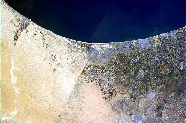
English: The border between Egypt (on the left side) and Gaza and Israel (on the right side) clearly visible from space. Pictured from the International Space Station.
The city of Rafah, split by the border into an Egyptian part and a Gazan part, is located at the center of the image. |
| Date | |
| Source | https://twitter.com/Cmdr_Hadfield/status/292412432998088705/photo/1 |
| Author | NASA/Chris Hadfield |
| Camera location | | View this and other nearby images on: OpenStreetMap |
|---|
Licensing
| This file is in the public domain in the United States because it was solely created by NASA. NASA copyright policy states that "NASA material is not protected by copyright unless noted". (See Template:PD-USGov, NASA copyright policy page or JPL Image Use Policy.) | ||
 |
Warnings:
|
| Annotations | This image is annotated: View the annotations at Commons |
File history
Click on a date/time to view the file as it appeared at that time.
| Date/Time | Thumbnail | Dimensions | User | Comment | |
|---|---|---|---|---|---|
| current | 07:29, 28 April 2013 | | 1,024 × 679 (151 KB) | Tanger | User created page with UploadWizard |
File usage
The following pages on the English Wikipedia use this file (pages on other projects are not listed):
Global file usage
The following other wikis use this file:
- Usage on ar.wikipedia.org
- Usage on cs.wikipedia.org
- Usage on he.wikipedia.org
- Usage on id.wikipedia.org
- Usage on it.wikipedia.org
- Usage on ro.wikipedia.org
- Usage on tr.wikipedia.org