
File:Border Guatemala-Mexico 1.jpg

Size of this preview: 800 × 600 pixels. Other resolutions: 320 × 240 pixels | 640 × 480 pixels | 1,024 × 768 pixels | 1,280 × 960 pixels | 2,560 × 1,920 pixels | 3,648 × 2,736 pixels.
Original file (3,648 × 2,736 pixels, file size: 4.33 MB, MIME type: image/jpeg)
| This is a file from the Wikimedia Commons. Information from its description page there is shown below. Commons is a freely licensed media file repository. You can help. |
Summary
| Description |
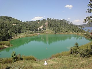
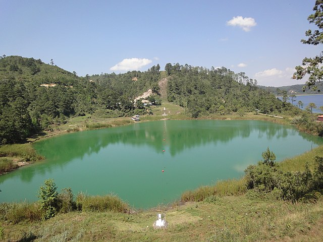
English: International border of Guatemala and Mexico: Guatemala on the left, Mexico on the right (in Lagunas de Montebello National Park).
Español: Frontera entre Guatemala (izquierda) y Mexico (derecha) en Lagunas de Montebello, Municipalidad de Nentón, Departamento de Huehuetenango, Guatemala. |
| Date | |
| Source | https://www.flickr.com/photos/grantsewell/4499414892/ |
| Author | grantsewell |
Licensing
This file is licensed under the Creative Commons Attribution-Share Alike 2.0 Generic license.
- You are free:
- to share – to copy, distribute and transmit the work
- to remix – to adapt the work
- Under the following conditions:
- attribution – You must give appropriate credit, provide a link to the license, and indicate if changes were made. You may do so in any reasonable manner, but not in any way that suggests the licensor endorses you or your use.
- share alike – If you remix, transform, or build upon the material, you must distribute your contributions under the same or compatible license as the original.
| This image was originally posted to Flickr by grantsewell at https://www.flickr.com/photos/12404620@N08/4499414892. It was reviewed on 00:17, 26 May 2010 (UTC) by FlickreviewR, who found it to be licensed under the terms of the cc-by-sa-2.0, which is compatible with the Commons. It is, however, not the same license as specified on upload, which was the cc-by-2.0, and it is unknown whether that license ever was valid. |
| Annotations | This image is annotated: View the annotations at Commons |
File history
Click on a date/time to view the file as it appeared at that time.
| Date/Time | Thumbnail | Dimensions | User | Comment | |
|---|---|---|---|---|---|
| current | 00:17, 26 May 2010 | | 3,648 × 2,736 (4.33 MB) | FlickreviewR | Replacing image by its original image from Flickr |
| 20:45, 25 May 2010 |  | 500 × 375 (128 KB) | Arjuno3 | {{Information |Description={{en|1=International border of Guatemala and Mexico: Guatemala on the left, Mexico on the right. Taken in Lagunas de Montebello, Municipality of Nentón, Huehuetenango department, Guatemala.}} {{es|1=Frontera entre Guatemala (iz |
File usage
The following pages on the English Wikipedia use this file (pages on other projects are not listed):
Global file usage
The following other wikis use this file:
- Usage on es.wikipedia.org
- Usage on hu.wikipedia.org
- Usage on it.wikipedia.org
- Usage on tr.wikipedia.org