
File:Boise Creek Fish Passage Proposal Feb 2010.jpg

Size of this preview: 800 × 598 pixels. Other resolutions: 320 × 239 pixels | 640 × 478 pixels | 934 × 698 pixels.
Original file (934 × 698 pixels, file size: 144 KB, MIME type: image/jpeg)
| This is a file from the Wikimedia Commons. Information from its description page there is shown below. Commons is a freely licensed media file repository. You can help. |
Summary
| Description |
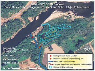
English: Map of plan to bypass bedrock falls on Boise Creek to create wetlands and bypass the barrier to fish passage. |
| Date | |
| Source | Emailed to me by the author |
| Author | Will Harling courtesy Mid-Klamath Watershed Council |
Licensing
This file is licensed under the Creative Commons Attribution-Share Alike 3.0 Unported license.
- You are free:
- to share – to copy, distribute and transmit the work
- to remix – to adapt the work
- Under the following conditions:
- attribution – You must give appropriate credit, provide a link to the license, and indicate if changes were made. You may do so in any reasonable manner, but not in any way that suggests the licensor endorses you or your use.
- share alike – If you remix, transform, or build upon the material, you must distribute your contributions under the same or compatible license as the original.
File history
Click on a date/time to view the file as it appeared at that time.
| Date/Time | Thumbnail | Dimensions | User | Comment | |
|---|---|---|---|---|---|
| current | 04:20, 10 July 2010 | | 934 × 698 (144 KB) | Schmiebel | {{Information |Description={{en|1=Map of plan to bypass bedrock falls on Boise Creek to create wetlands and bypass the barrier to fish passage.}} |Source=Emailed to me by the author |Author=Will Harling courtesy Mid-Klamath Watershed Council |Date=2009 |P |
File usage
The following pages on the English Wikipedia use this file (pages on other projects are not listed):