
File:Blackwood (Mon.) Station (remains) - geograph.org.uk - 1823454.jpg
No higher resolution available.
Blackwood_(Mon.)_Station_(remains)_-_geograph.org.uk_-_1823454.jpg (640 × 338 pixels, file size: 102 KB, MIME type: image/jpeg)
| This is a file from the Wikimedia Commons. Information from its description page there is shown below. Commons is a freely licensed media file repository. You can help. |
_Station_(remains)_-_geograph.org.uk_-_1823454.jpg)
Summary
| Description |
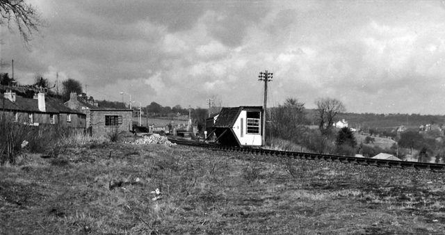
English: Blackwood (Mon.) Station (remains), near to Penmaen, Caerphilly/Caerffili, Great Britain. View northward, towards Argoed and Tredegar; ex-LNW Sirhowy Valley line (Nantybwch - Nine Mile Point - (Newport), closed to passengers 13/6/60 but only recently (8/2/65) to goods. What on earth has happened to the signalbox?! |
| Date | |
| Source | From geograph.org.uk; transferred by User:belaro using geograph_org2commons. |
| Author | Ben Brooksbank |
| Permission (Reusing this file) |
Creative Commons Attribution Share-alike license 2.0 |
| Camera location | | View this and other nearby images on: OpenStreetMap |
|---|
_Station_(remains)_-_geograph.org.uk_-_1823454.jpg¶ms=051.672716_N_-003.193862_E_globe:Earth_type:camera_heading:180.00_source:geograph&language=en)
| Object location | | View this and other nearby images on: OpenStreetMap |
|---|
_Station_(remains)_-_geograph.org.uk_-_1823454.jpg¶ms=051.672760_N_-003.193800_E_globe:Earth_class:object_type:object_source:geograph-osgb36(ST17549778)_region:GB-GBN_heading:180.00&language=en)
Licensing

|
This image was taken from the Geograph project collection. See this photograph's page on the Geograph website for the photographer's contact details. The copyright on this image is owned by Ben Brooksbank and is licensed for reuse under the Creative Commons Attribution-ShareAlike 2.0 license.
|
This file is licensed under the Creative Commons Attribution-Share Alike 2.0 Generic license.
Attribution: Ben Brooksbank
- You are free:
- to share – to copy, distribute and transmit the work
- to remix – to adapt the work
- Under the following conditions:
- attribution – You must give appropriate credit, provide a link to the license, and indicate if changes were made. You may do so in any reasonable manner, but not in any way that suggests the licensor endorses you or your use.
- share alike – If you remix, transform, or build upon the material, you must distribute your contributions under the same or compatible license as the original.
File history
Click on a date/time to view the file as it appeared at that time.
| Date/Time | Thumbnail | Dimensions | User | Comment | |
|---|---|---|---|---|---|
| current | 21:58, 23 January 2011 | | 640 × 338 (102 KB) | File Upload Bot (Magnus Manske) |
File usage
The following pages on the English Wikipedia use this file (pages on other projects are not listed):
Global file usage
The following other wikis use this file:
- Usage on www.wikidata.org
_Station_(remains)_-_geograph.org.uk_-_1823454.jpg)