
File:Blackfriars Station entrance geograph-3262754-by-Ben-Brooksbank.jpg

Size of this preview: 800 × 495 pixels. Other resolutions: 320 × 198 pixels | 640 × 396 pixels | 1,024 × 633 pixels | 1,280 × 792 pixels | 2,343 × 1,449 pixels.
Original file (2,343 × 1,449 pixels, file size: 2.72 MB, MIME type: image/jpeg)
| This is a file from the Wikimedia Commons. Information from its description page there is shown below. Commons is a freely licensed media file repository. You can help. |
Summary
| Description |
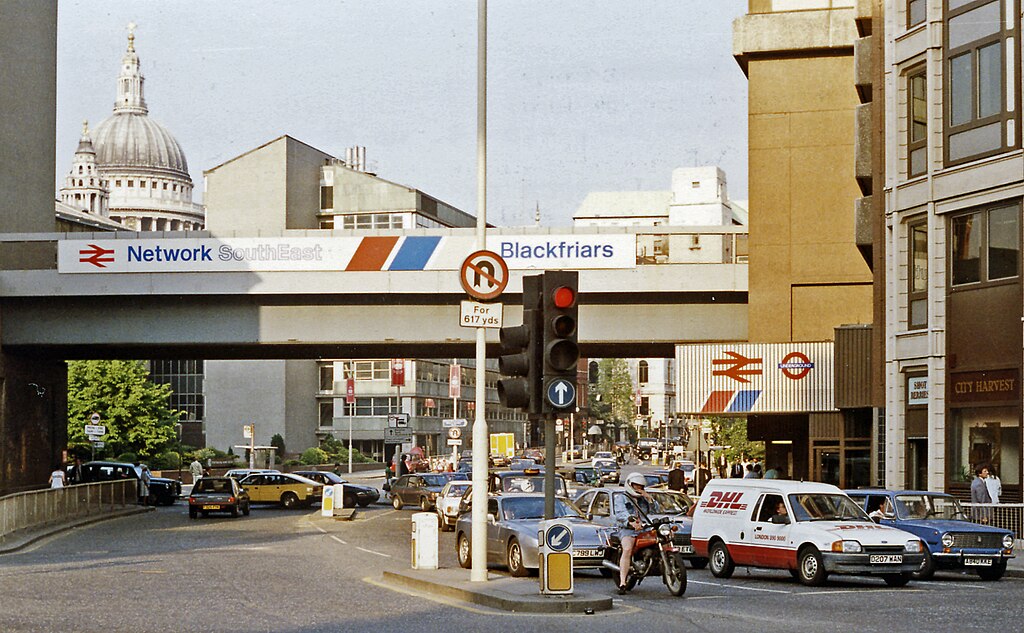
English: Outside Blackfriars Station, up Queen Victoria Street from New Bridge Street, 1989. View eastwards, with entrances on the right to the main (ex-SE&CR and Thameslink) and LT District and Circle Line) stations. The Thameslink service commenced in May 1988 and the bridge is now carrying Thameslink trains to/from Farringdon, King's Cross St Pancras, Luton and Bedford. (City Thameslink station was not yet built - it opened 29/5/90). St Paul's Cathedral is prominent on the left. |
| Date | |
| Source | From geograph.org.uk |
| Author | Ben Brooksbank |
| Permission (Reusing this file) |
Creative Commons Attribution Share-alike license 2.0 |
| Attribution (required by the license) | Ben Brooksbank / Outside Blackfriars Station, up Queen Victoria Street from New Bridge Street, 1989 / |
| Camera location | | View this and other nearby images on: OpenStreetMap |
|---|
Licensing

|
This image was taken from the Geograph project collection. See this photograph's page on the Geograph website for the photographer's contact details. The copyright on this image is owned by Ben Brooksbank and is licensed for reuse under the Creative Commons Attribution-ShareAlike 2.0 license.
|
This file is licensed under the Creative Commons Attribution-Share Alike 2.0 Generic license.
Attribution: Ben Brooksbank
- You are free:
- to share – to copy, distribute and transmit the work
- to remix – to adapt the work
- Under the following conditions:
- attribution – You must give appropriate credit, provide a link to the license, and indicate if changes were made. You may do so in any reasonable manner, but not in any way that suggests the licensor endorses you or your use.
- share alike – If you remix, transform, or build upon the material, you must distribute your contributions under the same or compatible license as the original.
File history
Click on a date/time to view the file as it appeared at that time.
| Date/Time | Thumbnail | Dimensions | User | Comment | |
|---|---|---|---|---|---|
| current | 11:38, 27 December 2012 | | 2,343 × 1,449 (2.72 MB) | Chevin | == {{int:filedesc}} == {{Information |Description={{en|1='''Outside Blackfriars Station, up Queen Victoria Street from New Bridge Street, 1989.'''<br/> View eastwards, with entrances on the right to the main (ex-SE&CR and Thameslink) and LT District an... |
File usage
The following pages on the English Wikipedia use this file (pages on other projects are not listed):
Global file usage
The following other wikis use this file:
- Usage on ur.wikipedia.org
- Usage on zh.wikipedia.org