
File:Berkeleyblue Jeffersonred.jpg
No higher resolution available.
Berkeleyblue_Jeffersonred.jpg (672 × 600 pixels, file size: 175 KB, MIME type: image/jpeg)
| This is a file from the Wikimedia Commons. Information from its description page there is shown below. Commons is a freely licensed media file repository. You can help. |
Summary
| Description |
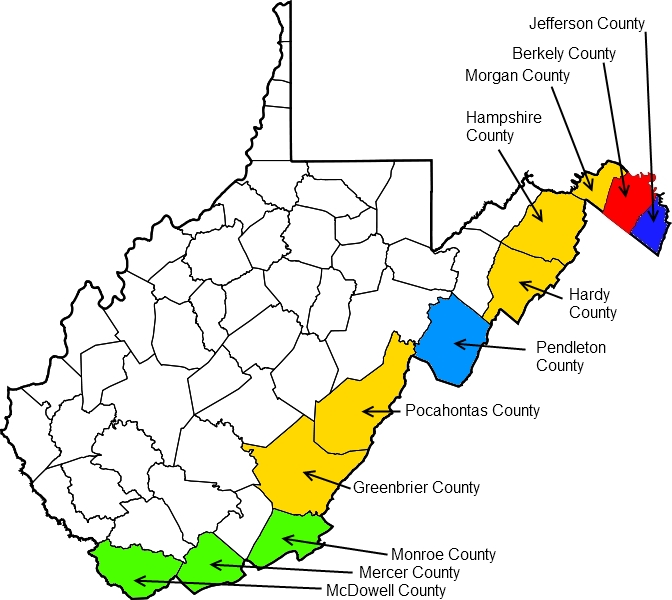
English: Map of the development of West Virginia covering the period June 19, 1861, to March 6, 1871. Counties in white are the original counties whose delegates authorized secession from the state of Virginia on August 6, 1861, at the Second Wheeling Convention. Berkeley County (red), Jefferson County (dark blue), and the counties marked in yellow were also authorized at this time to secede if their voters approved. Counties in green were added to the new state of West Virginia at the West Virginia constitutional convention, held November 26, 1861, to February 18, 1862. The county in light blue was offered the chance to join the new state during the constitutional convention if its voters approved. A legal dispute over the elections through which Berkeley and Jefferson counties seceded from Virginia was not resolved until the U.S. Supreme Court's decision in Virginia v. West Virginia, 78 U.S. 39 (1871). |
| Date | |
| Source | Own work |
| Author | Tim1965 |
Licensing
I, the copyright holder of this work, hereby publish it under the following licenses:
This file is licensed under the Creative Commons Attribution-Share Alike 3.0 Unported license.
- You are free:
- to share – to copy, distribute and transmit the work
- to remix – to adapt the work
- Under the following conditions:
- attribution – You must give appropriate credit, provide a link to the license, and indicate if changes were made. You may do so in any reasonable manner, but not in any way that suggests the licensor endorses you or your use.
- share alike – If you remix, transform, or build upon the material, you must distribute your contributions under the same or compatible license as the original.

|
Permission is granted to copy, distribute and/or modify this document under the terms of the GNU Free Documentation License, Version 1.2 or any later version published by the Free Software Foundation; with no Invariant Sections, no Front-Cover Texts, and no Back-Cover Texts. A copy of the license is included in the section entitled GNU Free Documentation License. |
You may select the license of your choice.
File history
Click on a date/time to view the file as it appeared at that time.
| Date/Time | Thumbnail | Dimensions | User | Comment | |
|---|---|---|---|---|---|
| current | 14:55, 13 August 2010 | | 672 × 600 (175 KB) | Tim1965 | {{Information |Description={{en|1=Map of the development of West Virginia covering the period June 19, 1861, to March 6, 1871. Counties in white are the original counties whose delegates authorized secession from the state of Virginia on August 6, 1861, a |
File usage
The following pages on the English Wikipedia use this file (pages on other projects are not listed):
Global file usage
The following other wikis use this file:
- Usage on ro.wikipedia.org
- Format:Virginia de Vest stat SUA
- Categorie:Guvernatori ai statului West Virginia
- Virginia de Vest
- Listă de oameni din statul Virginia de Vest
- Listă de orașe din statul Virginia de Vest
- Comitatul Wayne, Virginia de Vest
- Categorie:Zona micropolitană Bluefield
- Listă de comitate din statul Virginia de Vest
- Categorie:Comitatul Pocahontas, Virginia de Vest
- Categorie:Zona metropolitană Pittsburgh
- Categorie:Reședințe de comitate din Virginia de Vest
- Categorie:Oameni din Virginia de Vest după comitat
- Categorie:Politicieni din statul Virginia de Vest
- Categorie:Membri ai Senatului SUA din statul Virginia de Vest
- Categorie:Membri ai Camerei Reprezentanților SUA din statul Virginia de Vest
- Categorie:Membri ai legislaturii statului Virginia de Vest
- Categorie:Comitatul Barbour, Virginia de Vest
- Categorie:Zone metropolitane din Virginia de Vest
- Categorie:Localități din Virginia de Vest
- Categorie:Absolvenți din Virginia de Vest după instituția de învățământ superior
- Categorie:Târguri din statul Virginia de Vest
- Categorie:Municipalități din statul Virginia de Vest
- Categorie:Insule ale statului Virginia de Vest
- Categorie:Zone micropolitane din Virginia de Vest
- Categorie:Liste Virginia de Vest
- Categorie:Sate din statul Virginia de Vest
- Categorie:Locuri desemnate pentru recensământ statul Virginia de Vest
- Categorie:Subdiviziunile statului Virginia de Vest
- Categorie:Istoria naturală a statului Virginia de Vest
- Categorie:Dezastre naturale din statul Virginia de Vest
- Categorie:Dezastre din statul Virginia de Vest
- Categorie:Guvernul statului Virginia de Vest
- Categorie:Politica statului Virginia de Vest
- Categorie:Legislatura statului Virginia de Vest
- Categorie:Actori din statul Virginia de Vest
- Categorie:2012 în statul Virginia de Vest
- Categorie:Ani în Virginia de Vest
- Categorie:Uragane în statul Virginia de Vest
- Categorie:Oameni din Virginia de Vest după localitate
- Categorie:Istoria statului Virginia de Vest după perioadă
- Categorie:Decenii în statul Virginia de Vest
- Categorie:Secole în istoria statului Virginia de Vest
- Categorie:Milenii în istoria statului Virginia de Vest
- Categorie:Mileniul al III-lea în statul Virginia de Vest
- Categorie:Mileniul al II-lea în statul Virginia de Vest
- Categorie:Orașe din Virginia de Vest după comitat
- Comitatul Barbour, Virginia de Vest
- Comitatul Berkeley, Virginia de Vest
- Comitatul Boone, Virginia de Vest
- Comitatul Braxton, Virginia de Vest
View more global usage of this file.