
File:Belle Grove, Rappahannock River, Port Royal, Caroline County, VA.jpg

Size of this preview: 800 × 569 pixels. Other resolutions: 320 × 228 pixels | 640 × 455 pixels | 939 × 668 pixels.
Original file (939 × 668 pixels, file size: 286 KB, MIME type: image/jpeg)
| This is a file from the Wikimedia Commons. Information from its description page there is shown below. Commons is a freely licensed media file repository. You can help. |
Summary
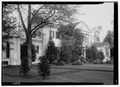
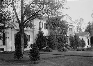
| English: Belle Grove, Rappahannock River, Port Royal, Caroline County, VA
( |
||||||||||||||||||||||||
|---|---|---|---|---|---|---|---|---|---|---|---|---|---|---|---|---|---|---|---|---|---|---|---|---|
| Photographer |
Thomas T. Waterman |
|||||||||||||||||||||||
| Title |
English: Belle Grove, Rappahannock River, Port Royal, Caroline County, VA |
|||||||||||||||||||||||
| Description |
English: Belle Grove, Rappahannock River, Port Royal, Caroline County, VA HABS VA,50-POCON.V,2--1 |
|||||||||||||||||||||||
| Date | 1941 | |||||||||||||||||||||||
| Medium | 5 x 7 in. | |||||||||||||||||||||||
| Collection |
|
|||||||||||||||||||||||
| Accession number |
HABS VA,50-POCON.V,2--1 |
|||||||||||||||||||||||
| Source |
|
|||||||||||||||||||||||
| Permission (Reusing this file) |
Rights Advisory: No known restrictions on publication. | |||||||||||||||||||||||
| Other versions |
|
|||||||||||||||||||||||


| Camera location | | View this and other nearby images on: OpenStreetMap |
|---|
Licensing

|
This file comes from the Historic American Buildings Survey (HABS), Historic American Engineering Record (HAER) or Historic American Landscapes Survey (HALS). These are programs of the National Park Service established for the purpose of documenting historic places. Records consist of measured drawings, archival photographs, and written reports.
|
| This image or media file contains material based on a work of a National Park Service employee, created as part of that person's official duties. As a work of the U.S. federal government, such work is in the public domain in the United States. See the NPS website and NPS copyright policy for more information. |
File history
Click on a date/time to view the file as it appeared at that time.
| Date/Time | Thumbnail | Dimensions | User | Comment | |
|---|---|---|---|---|---|
| current | 16:32, 14 March 2013 | | 939 × 668 (286 KB) | Slowking4 | User created page with UploadWizard |
File usage
The following pages on the English Wikipedia use this file (pages on other projects are not listed):
Global file usage
The following other wikis use this file:
- Usage on tr.wikipedia.org
- Usage on www.wikidata.org